
Pars orbis
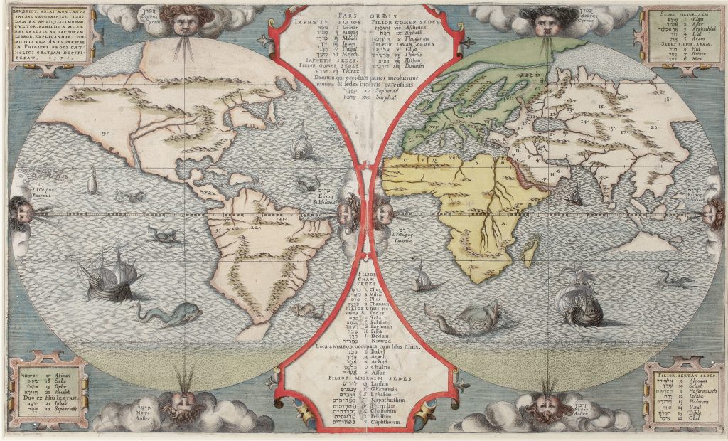
Between 1569 and 1572, Christopher Plantin produced his monumental eight-volume Biblia Sacra Hebraice, Chaldaice, Graece et Latine, commonly known as the Biblia Regia or Plantin Polyglot.
The project was undertaken under the patronage of King Philip II of Spain and supervised by the Spanish humanist Benito Arias Montanus.
This world map was engraved in 1571 and published in the final volume in 1572.
It was conceived as a visual counterpart to the biblical scholarship of the Polyglot Bible.
Rather than presenting the world only as a geographic space, it organises it through sacred history, tracing the descendants of Noah’s sons, Shem, Ham, and Japheth, across the known world after the Flood.
The map is arranged in two hemispheres, with the Old World on the right and the Americas on the left.
A central panel lists genealogical names in Hebrew and Latin, while alphabetical and numerical references link these names to places on the map.
In this way, geography becomes a framework for biblical descent, migration, and settlement.
The surrounding imagery reinforces the map’s cosmographical character.
Wind heads mark the directions, while ships and sea creatures animate the oceans.
The map incorporates sixteenth-century geographic knowledge, but its main purpose is interpretive: it presents the world as a divinely ordered space, structured by scripture and human genealogy.
According to Rodney Shirley the map is known from three plates, the first of which exists in two states.
This example is the first state of the first plate, dated 1571 in the upper-left cartouche.
In this state, the word “Iektan” appears at the end of the third line in the lower-left text panel.
In the second state of the first plate, issued in 1572, “gentes” was added beneath “Iektan.”.
The second plate, possibly issued in 1572, introduces more substantial changes: the wind heads face different directions; there is less engraved sea below the Antarctic Circle; the date 1571 is repositioned onto its own line in the upper-left text panel; and “gentes” appears on the same line as “Ioktan” (spelled “Iektan” in the first plate) in the lower-left text panel.
The later third plate, issued in London in 1660, appears in Critici Sacri with the text “Tom: VI. pag. 553.” in the lower-left margin (474).
In this plate, the wind heads are shown with closed eyes, and the sea is revised with different ships and sea creatures.
Arias Montanus, Benedictus (1527–1598)
Biblia Sacra Hebraice, Chaldaice, Graece et Latine vol. 8, Antwerp: Christopher Plantin, 1572-73
1571, first plate, state 1
Copperplate engraving
111
R2 Very rare - one or two copies appear on the market