
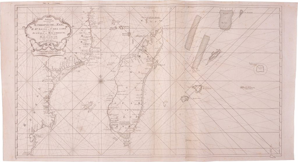
Paskaart van een Gedeelte van de Aethiopische Zee
The Van Keulen publishing house, In de Gekroonde Lootsman (“In the Crowned Pilot”), was founded in Amsterdam by Johannes van Keulen I in 1678 and became one of the leading Dutch firms producing maps, sea charts, atlases, and pilot books.
After Johannes I and his son Gerard developed the business, it passed to Gerard’s son, Johannes van Keulen II.
In the mid-eighteenth century, the firm issued both atlas charts and separately published working charts for VOC navigation, including large-format charts of the Indian Ocean and African coasts.
The fuller title wording records: Paskaart van een Gedeelte van de AEthiopische Zee strekkende van R.
Sta Lucia tot C. del Gado langs de kusten van Suffalo en Mocambique, bevattende insgelyks 't Eiland Madagascar, met desselfs onderhorige Eilanden.
This chart covers the southern and central part of the western Indian Ocean, then commonly described in Dutch hydrography as part of the Aethiopische Zee.
First published separately in Amsterdam in 1726, this example represents the expanded eastern loose-chart version, issued between c. 1726 and 1755.
Unlike the narrower version later included in De nieuwe groote lichtende Zee-fakkel, vol. 6, in 1753, this loose chart extends farther east into the central Indian Ocean.
The chart extends from Cabo del Gado to Rio de Santa Lucia, covering the coasts of Sofala and Mozambique, Madagascar and its surrounding islands, and the island systems of the central Indian Ocean.
Its expanded eastern section records hazards and landfalls faced by ships crossing the Indian Ocean, including Réunion, Mauritius, Rodrigues, St Brandon, and numerous reefs and shoals.
It therefore links the East African coast and Madagascar with the wider oceanic routes leading toward India, Ceylon, and the East Indies.
Rhumb lines, compass roses, latitude markings, coastal names, anchorages, soundings, islands, banks, and shoals show its practical function as a sea chart.
It was made not simply to describe coastlines, but to guide movement across long and difficult routes linking the Cape passage, East Africa, Madagascar, the central Indian Ocean, India, Ceylon, and the East Indies.
This chart is closely connected with Van Keulen’s northern chart of the same sea (465), which covers Zanguebar, Ajan, Abex, the Arabian coast, the Red Sea entrance, and islands toward the longitude of the Maldives.
It also connects with Van Keulen’s Maldives chart (305), Red Sea entrance chart (306), and the large VOC chart from the Cape of Good Hope to Canton (270).
Together, these works show how Van Keulen mapped the Indian Ocean as a system of passages, hazards, island groups, and coastal approaches essential to VOC navigation.
Keulen II, Johannes van (1704–1755)
Separate publication.
Amsterdam: Johannes van Keulen II, 1726
1726–1755, expanded eastern loose-chart version
Narrower version included in De nieuwe groote lichtende Zee-fakkel, vol. 6, Amsterdam, 1753
Copperplate engraving
467
R1 Extremely rare - occasionally seen on the market