
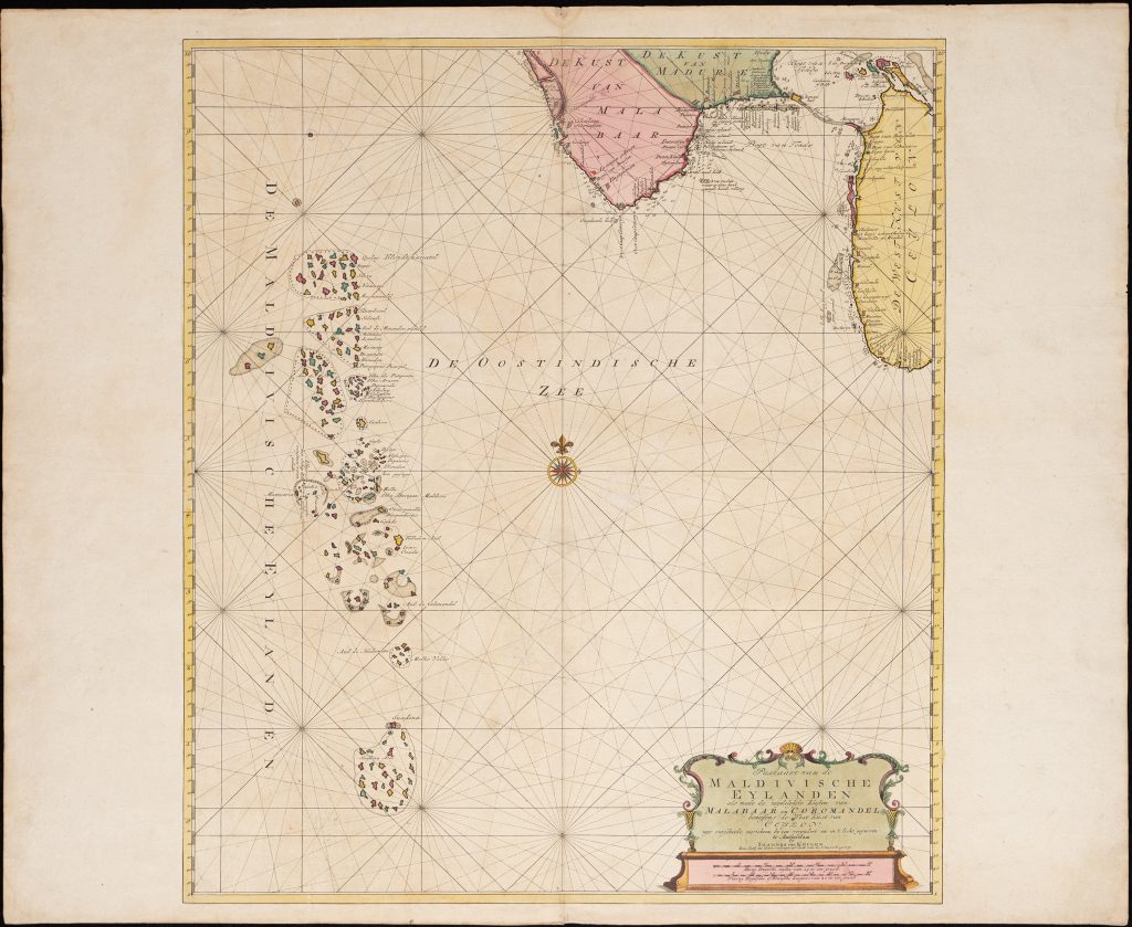
Paskaart van de Maldivische Eylanden
The Van Keulen publishing house, In de Gekroonde Lootsman (“In the Crowned Pilot”), was founded in Amsterdam by Johannes van Keulen I in 1678 and became one of the leading Dutch firms producing maps, sea charts, atlases, and pilot books.
After Johannes I and his son Gerard developed the business, it passed to Gerard’s son, Johannes van Keulen II.
Johannes II is especially known for issuing the sixth and final volume of De nieuwe groote lichtende Zee-fakkel in 1753, devoted to Asian and Indian Ocean navigation.
The volume brought into print closely guarded VOC hydrographic knowledge, including information derived from manuscript charts and sailing directions that had previously been restricted because of their commercial and strategic value.
The fuller title wording records: Paskaart van de Maldivische Eylanden: als mede de zuydelykste kusten van Malabaar en Coromandel, beneffens de west kust van Ceylon uyt verscheide narichten by een vergadert en in 't licht gegeeven Datum.
The Zee-fakkel included this sea chart of the Maldives with the southern coasts of Malabar and Coromandel and the west coast of Ceylon also included.
The Maldives were not a major VOC trading centre, but their long chains of low coral atolls, reefs, and uncertain passages made them a major navigational hazard for ships sailing between the Cape of Good Hope, Ceylon, India, and the East Indies.
VOC sailing instructions warned vessels to avoid the Maldives where possible, or to proceed with great caution if avoidance was impossible, especially at night.
The chart records atolls, channels, reefs, shoals, soundings, anchorages, and coastal reference points, giving pilots the information needed to negotiate or avoid these dangerous waters.
The chart also marks the wreck of the VOC ship Ravenstein, an East Indiaman from the Zeeland chamber, lost in 1726 on an outer reef of Ari Atoll.
This wreck reference turns the chart into both a navigational guide and a warning.
The sheet also shows Dutch trading posts and strongholds in India and Ceylon, connecting the Maldives to the wider VOC route system across the northern Indian Ocean.
This chart is closely connected with Van Keulen’s Red Sea entrance chart (306), the large VOC chart from the Cape of Good Hope to Canton (270), and the Aethiopian Sea charts of the western Indian Ocean (465and 467).
Together, these works show the importance of hazard mapping, reef systems, and sailing routes in Dutch navigation between Africa, India, Ceylon, and the East Indies.
Keulen II, Johannes van (1704–1755)
De nieuwe groote lichtende Zee-fakkel, vol. 6, Amsterdam: Johannes van Keulen II, 1753
1753, first
Copperplate engraving
305
R2 Very rare - one or two copies appear on the market