
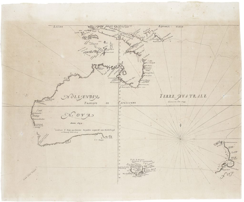
Hollandia nova detecta 1644 / Terre Australe decouverte l'an 1644
Melchisédech Thévenot was a French scholar, traveller, orientalist, scientist, and editor whose Relations de divers voyages curieux brought together important accounts of travel and exploration. The first part appeared in 1663, the second in 1664, the third in 1666, and the fourth in 1672, with later reissues and a final augmented form in 1696. Because sheets, plates, and maps were printed, reprinted, gathered, and bound in varying ways, surviving copies often differ in contents, pagination, and map states.
This map appeared in the first part of the collection, where it accompanied Thévenot’s abridged French translation of Francisco Pelsaert’s account of the 1629 Batavia shipwreck and mutiny, La terre Australe descouverte par le capitaine Pelsart. Its placement beside the Pelsaert narrative linked the map of Hollandia Nova to one of the most dramatic Dutch encounters with the Australian coast. Based on Dutch VOC material, especially Abel Jansz. Tasman’s 1644 voyage, the map played an important role in disseminating Dutch discoveries in Australia to French and wider European readers. This example is the fourth state, c. 1672–74. According to Dewez, Thévenot’s map is known in six states, each marked by changes to the printed plate. In the earliest state (171), the map has no rhumb lines, the Tropic of Capricorn is named but not drawn across the map, the latitude numbers contain errors, and Tasman’s 1642–43 voyage track is not shown. In this fourth state, those latitude errors have been corrected, rhumb lines have been added, and the Triall Islands have been inserted off the northwest coast of Australia. Later states add the plate number “19” and, in the sixth state, Tasman’s first-voyage track.
The map records key Dutch explorations around Australia and Cape York Peninsula, including Dirk Hartog’s 1616 landfall on the west coast, Frederik de Houtman’s observations in 1619, the Leeuwin discoveries in the southwest in 1622, Jan Carstensz. and Willem Joosten van Colster’s northern discoveries in 1623, Pieter Nuyts’s mapping of the southern coast in 1627, Gerrit Frederiksz. de Witt’s west-coast discoveries in 1628, and Abel Jansz. Tasman’s 1644 survey of the northern coast. Australia is labelled Hollandia Nova, while the eastern side remains open and The verso of this copy contains five genealogical tables in Arabic script relating to Islamic dynasties and rulers. These include the Abbasid caliphs in Baghdad under Seljuk rule, the Ghaznavid dynasty, the sultans of the Great Seljuk Empire, the Nizari Ismaili imams, and the Ottoman sultans. The Ottoman sequence ends with Mehmed IV, who reigned from 1648 to 1687.
Within the collection, this fourth state is directly connected with the first state of the same map (171).
Thévenot, Melchisédech (1620–1692)
Relations de divers voyages curieux, part 1, Paris: Jacques Langlois, 1663
1672–74, fourth
Copperplate engraving
32