
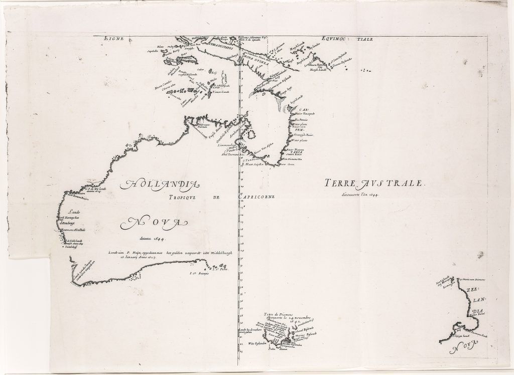
Hollandia nova detecta 1644 / Terre Australe decouverte l'an 1644
Melchisédech Thévenot was a French scholar, traveller, orientalist, scientist, and editor whose Relations de divers voyages curieux brought together important accounts of travel and exploration. Published in Paris from 1663, the collection made rare or manuscript geographical knowledge available to a wider European readership. The first part appeared in 1663, the second in 1664, the third in 1666, and the fourth in 1672, with later reissues and a final augmented form in 1696. Because sheets, plates, and maps were printed, reprinted, gathered, and bound in varying ways, surviving copies often differ in contents, pagination, and map states.
This map was included in part 1 of Thévenot’s work where it accompanied his abridged French translation of Francisco Pelsaert’s dramatic account of the 1629 Batavia shipwreck and mutiny, La terre Australe descouverte par le capitaine Pelsart. Its placement beside the Pelsaert narrative linked the map of Hollandia Nova to one of the most dramatic Dutch encounters with the Australian coast. Based on Dutch VOC material, especially Abel Jansz. Tasman’s 1644 voyage, the map played an important role in disseminating Dutch discoveries in Australia to French and wider European readers. This example is the first state, c. 1663. According to Dewez, Thévenot’s map is known in six states. In the first state, represented here, the map lacks rhumb lines and does not yet include the drawn Tropic of Capricorn, although the name is present. The latitude numbering is erroneous, omitting “3” and placing “4” where “5” should appear, and Tasman’s 1642–43 track is absent. Later states progressively add the Tropic of Capricorn, correct the latitude numbering, add rhumb lines, incorporate the Triall Islands, add the plate number “19, ” and finally add Tasman’s first-voyage track.
The map records key Dutch explorations around Australia and Cape York Peninsula, including Dirk Hartog’s 1616 landfall on the west coast, Frederik de Houtman’s observations in 1619, the Leeuwin discoveries in the southwest in 1622, Jan Carstensz. and Willem Joosten van Colster’s northern discoveries in 1623, Pieter Nuyts’s mapping of the southern coast in 1627, Gerrit Frederiksz. de Witt’s west-coast discoveries in 1628, and Abel Jansz. Tasman’s 1644 survey of the northern coast. Australia is labelled Hollandia Nova, while the eastern side remains open and
Within the collection, this first state is directly connected with the fourth state of the same map (32).
Thévenot, Melchisédech (1620–1692)
Relations de divers voyages curieux, part 1, Paris: Jacques Langlois, 1663
1663, first
Copperplate engraving
171
R2 Very rare - one or two copies appear on the market