
't Vergulde licht der zee-vaard, ofte konst der stuurlieden
Klaas Hendriksz. Gietermaker was a Dutch mathematician and navigation teacher whose 't Vergulde licht der zee-vaard, ofte konst der stuurlieden became a practical manual for pilots and helmsmen. First published in Amsterdam by Hendrick Doncker in 1660, the work explained the mathematical and technical knowledge expected of a working navigator, including calculation, tables, coastal sailing, latitude, longitude, compass use, and the interpretation of navigational problems at sea.
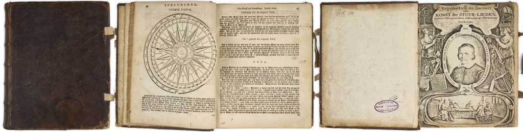
The book belonged to a long tradition of Dutch nautical manuals designed to educate and guide navigators in the context of the Dutch maritime world. It remained in use well into the eighteenth century and was revised through multiple editions to reflect the continuing needs of students, pilots, and exam candidates. Fourteen editions are recorded. The title page depicts a portrait of Gietermaker, allegorical female figures and navigational instruments. At the bottom, a navigation class is shown taking place around a table, reinforcing the book’s function as a teaching text. The missing imprint read: t'Amsterdam, bij Gerard van Keulen, gedrukt — “Printed at Amsterdam by Gerard van Keulen.”
The work combines instruction, diagrams, and numerical tables. The second part contains detailed tables of sines, tangents, secants, and logarithms, designed to make navigational calculation more accurate and less prone to error. The title page to this section is decorated with a naval battle, linking mathematical navigation to the practical world of seafaring. An interesting southern-hemisphere connection appears in the final table, headed De Son Evenaers Zuyder Breede. This can be understood as the sun’s southern declination from the equator, a key value for navigators calculating latitude from solar observations. The table covers southern declinations between 0 and 12 degrees, with explanatory text below on how it should be used. Rather than being a map of southern waters, it shows how printed navigational manuals equipped Dutch seafarers to calculate position in equatorial and southern latitudes.
Within the collection, this manual is closely connected with Hendrick Doncker’s sea atlases and charts, since Doncker first published Gietermaker’s navigational manual in 1660 and also issued practical charts for Dutch seafarers.
Gietermaker, Klaas Hendriksz. (1621–before 1677)
't Vergulde licht der zee-vaard, ofte konst der stuurlieden, Amsterdam: Gerard van Keulen, 1660
1757
Letterpress with engraved title pages and diagrams
342
R2 Very rare - one or two copies appear on the market