
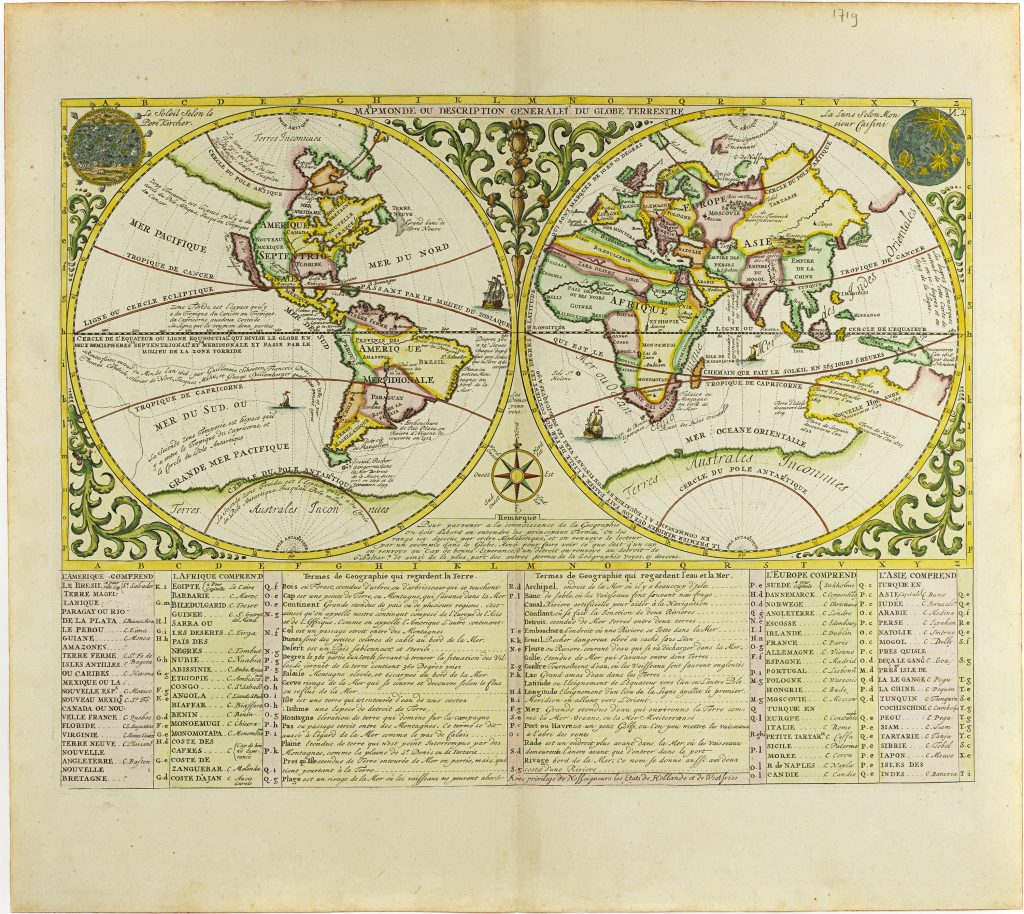
Mapmonde ou description generale du globe terrestre
Zacharie Châtelain was a Huguenot publisher and compiler active in Amsterdam, now generally regarded as the principal compiler of the Atlas historique, although the work has traditionally been attributed to Henri Abraham Châtelain. Published between 1705 and 1720, the Atlas historique combined geography, chronology, history, genealogy, politics, religion, commerce, and travel, making it one of the most ambitious illustrated geographical encyclopaedias of the early eighteenth century. Its maps, views, diagrams, and historical essays were intended not simply to describe the world, but to place geographical knowledge within a broader framework of history and human affairs. The work was also rich in material concerning civil, military, commercial, and ecclesiastical governance, including plates on the Dutch East India Company (249) and the States of the Seven United Provinces (250).
The Atlas historique includes numerous maps, often drawing on contemporary French cartography and geographical compilation. This double-hemisphere world map was one of two world maps included in volume 1, first published in 1705; this example belongs to a later 1719 issue of the atlas. The other world map from volume 1 is also represented in this collection 248. The map presents the world through a combination of geographical outline, astronomical reference, explanatory text, and voyage history. The upper corners contain representations of the Sun, after Athanasius Kircher, and the Moon, after Giovanni Domenico Cassini, while a compass rose between the hemispheres reinforces the map’s didactic function.
Below the hemispheres, a table explains how to read the map and defines geographical terms relating to land and sea. It also lists the four continents and their principal places, presenting geography as ordered knowledge rather than simply as spatial representation. Across the oceans, the routes and dates of major voyages are marked, including those associated with Francis Drake, Thomas Cavendish, Olivier van Noort, Jacques Mahu, Guillaume Schouten, and Joris van Spilbergen. Small engraved ships animate the oceans and connect the map to the history of European navigation.
The Western Hemisphere shows North and South America, with French colonial interests in North America and California depicted as an island. The Eastern Hemisphere includes Europe, Africa, and Asia, with part of Nouvelle Hollande shown in the south. The incomplete Australian coastline is linked to Terres Australes Inconnues, reflecting the persistence of the unknown southern continent in early eighteenth-century European mapping. The map belongs with Châtelain’s second world map in this collection (248), which more specifically addresses Dutch overseas power and the global reach of the trading companies.
Chatelain, Henri Abraham (1684–1743)
Atlas historique, ou nouvelle introduction à l’histoire, à la chronologie & à la géographie ancienne & moderne, vol. 1, Amsterdam: L’Honoré & Châtelain, 1705
TBA
Copperplate engraving
247
R3 Uncommon - dealers can usually obtain a copy