
Descripcion de las Indias Ocidentalis
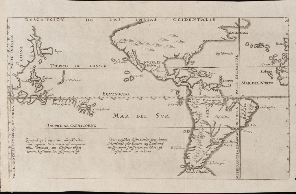
Antonio de Herrera y Tordesillas was a Spanish historian and royal chronicler whose Descripción de las Indias Occidentales was first published in Madrid by the Imprenta Real in 1601. The work drew on the earlier geographical compilations of Juan López de Velasco, whom Philip II had commissioned in 1571 to prepare a comprehensive account of Spain’s overseas territories. López de Velasco completed his Geografía y descripción universal de las Indias in manuscript in 1574, apparently accompanied by maps that are not known to survive. He later prepared a shorter version, the Demarcación y división de las Indias, or Sumario, which included a map known as Demarcación y navegaciones de Indias. Herrera incorporated this geographical tradition into his Descripción, making the map widely available through print.
This example is the 1623 De Bry version, published in the twelfth part of the German India Occidentalis, Zwolffter Theil der Newen Welt. The map depicts the Americas and the Pacific, extending from the Atlantic coast of Africa and Europe across the Americas to the Philippines, the Moluccas, New Guinea, Japan, and parts of East and Southeast Asia. It is structured by the equator, the Tropics of Cancer and Capricorn, and the marked meridians of demarcation that divided Spanish and Portuguese spheres under the Treaty of Tordesillas and subsequent Iberian claims. The map circulated in several published forms: Herrera’s 1601 version, with the South Pacific text in a cartouche; Herrera’s 1622 version, with the text but without the cartouche; the 1623 De Bry version, as here, with two South Pacific inscriptions in Latin and German; a reduced 1623 Hulsius version; and later eighteenth-century versions associated with Torquemada and Rodríguez. These changes show how the map moved from Spanish imperial geography into northern European and later historical compilations.
The map functions as a visual statement of Spanish imperial geography. It presents the Americas and Pacific within the framework of Iberian demarcation, showing the lands and seas claimed for Castile between the marked meridians. Its placement of the Philippines and the Moluccas, or Spice Islands, approximately forty degrees too far east is geographically inaccurate, but politically significant: the displacement places these contested islands more firmly within the Castilian sphere at a time when Spain and Portugal continued to dispute authority in the western Pacific. The South Pacific inscriptions explain the map’s imperial logic. They state that whatever had been discovered by voyages between the two marked meridians, whether on land or water, was assigned to the Castilians. The German text similarly reads: Was zwischen diesen beiden gezeichneten Meridianen oder Linien zu Land und Wasser durch Schifffahrten entdeckt, ist den Castilianern zuerkannt — “What has been discovered by navigation between these two marked meridians or lines, on land and water, is assigned to the Castilians.”
Within the collection, this map is closely connected with Hessel Gerritsz.’s world maps with the Quirós inscription (99and 101), Jacques L’Hermite’s Journael vande Nassausche Vloot (55), and Pieter Goos’s Pascaerte Vande Zuyd-Zee (466). Together, these works show how European maps and voyage books represented the Pacific as a space of imperial claims, contested routes, and uncertain southern geography.
Herrera y Tordesillas, Antonio de (1549–1625)
Descripción de las Indias Madrid: Imprenta Real, 1601
1623, German / Latin issue from Zwolffter Theil der Newen Welt
Copperplate engraving
337
R3 Uncommon - dealers can usually obtain a copy