
World map
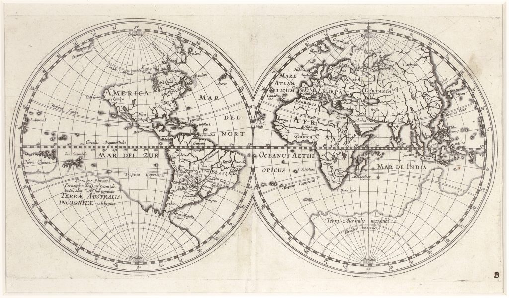
Hessel Gerritsz. was a Dutch engraver, publisher, and cartographer who trained in the circle of Willem Jansz. Blaeu before establishing himself independently in Amsterdam. In 1617 he became the first exclusive mapmaker to the Dutch East India Company, or VOC, a position that placed him at the centre of Dutch hydrographic and overseas cartography. This small, untitled double-hemisphere world map was issued in 1612 in Gerritsz.’s Beschryvinghe vander Samoyeden Landt in Tatierien, a work concerned with Samoyed Land, Tatary, Arctic geography, and routes toward Asia. Gerritsz. is widely associated with the 1612 world map incorporating Pedro Fernandes de Quirós’s southern discoveries.
The map is especially revealing in its treatment of the southern continent. Across the large southern land appears the inscription Terra per Petrum Fernandez de Quir recens detecta, olim verò sub nomine Terrae Australis Incognitae celebrata — “Land recently discovered by Pedro Fernandes de Quirós, formerly celebrated under the name Terra Australis Incognita.” Quirós had sailed with Álvaro de Mendaña’s 1595–1596 expedition before leading his own 1605–1606 voyage in search of the southern continent. His claimed discovery, Austrialia del Espíritu Santo, is now understood as part of Vanuatu rather than the continental landmass he imagined.
Gerritsz.’s map helped carry Quirós’s claims into Dutch print and gave them a prominent place within a global cartographic image. The southern continent is not merely decorative: it is connected to recent voyage reporting, Spanish imperial aspiration, and the continuing European search for a great southern land. The map therefore stands at an important point between the older speculative Terra Australis Incognita and later European attempts to identify, name, and chart lands in the South Pacific.
Within the collection, this first Dutch issue should be compared with the Latin issue of the same year (101), which alters the North American geography. It also relates to other world maps in the collection that give visual form to the southern continent, including Oronce Fine’s double cordiform world map (88), the world map by Petrus Plancius from Jan Huygen van Linschoten’s Itinerario (71), Hendrik Doncker’s later world map (23), and Philipp Eckebrecht’s world map (125). Together, these works show how Terra Australis moved between classical inheritance, voyage report, and early modern global cartography.
Gerritsz., Hessel (1581–1632)
Beschryvinghe vander Samoyeden Landt in Tatierien, Amsterdam: Hessel Gerritsz., 1612
1612, first Dutch issue
Copperplate engraving
99
R2 Very rare - one or two copies appear on the market