
Chica sive Patagonica et Australis Terra
Matthias Quad was a Netherlandish engraver, cartographer, and geographical writer active in Cologne. Working with Johann Bussemacher, he produced small-format maps for geographical handbooks that adapted larger Netherlandish and Flemish geographical works for a German readership.
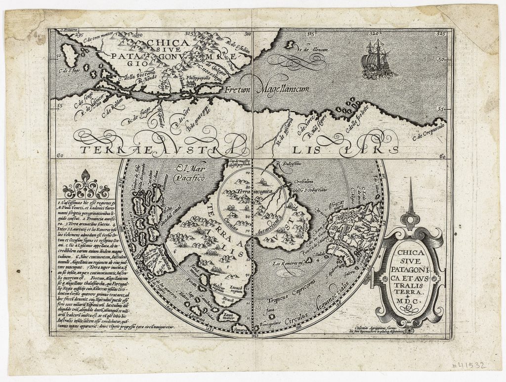
In 1600, Quad published the Geographisch Handtbuch, a compact compendium of geographical and historical knowledge that included maps. Among these was Chica sive Patagonica et Australis Terra, one of the early printed maps devoted specifically to the far southern hemisphere. It is closely related to Cornelis Wytfliet’s 1597 map (176) of the same subject and Jean Metellus’s 1598 version (226), but Quad’s plate belongs to his own Cologne publication context rather than being a state of either earlier map. The sheet is arranged in two parts. The upper panel focuses on the Strait of Magellan, Patagonia, Tierra del Fuego, and the northern edge of the southern land. The naming of C. della Victoria and the ship shown in the strait recall Magellan’s Victoria, the only vessel of his expedition to complete the circumnavigation. The lower circular map uses a south polar projection to show Terra Australis spreading around the Antarctic pole and extending in broad projections towards South America, southern Africa, Java Maior, New Guinea, and the western Pacific.
The map preserves the belief that the lands south of the Strait of Magellan formed part of a greater southern continent. Tierra del Fuego is not treated as an island in the modern sense, but as part of the northern edge of Terra Australis. The lower map also includes inherited southern names such as Beach, Lucach regnum, and Maletur regnum, drawn from the European reception of Marco Polo and related travel literature. Their presence gives the speculative continent an apparent textual and geographical authority. The long Latin text at left explains the uncertain status of the southern land. It describes Terra Australis as the southernmost of all countries, extending towards the polar circle but also reaching northwards towards the tropics and the equator. It places the land near New Guinea, separated only by a narrow strait, and notes that it had been explored only at a few coastal places. The text even raises the possibility that, if fully discovered, it might prove to be a fifth continent.
Within the collection, this map is closely connected with Quad’s world map (461), where Terra Australis nondum cognita appears in world-map form.
Quad, Matthias (1557–1613)
Geographisch Handtbuch, Cologne: Johann Bussemacher, 1600
1600, first
Copperplate engraving
198
R1 Extremely rare - occasionally seen on the market