
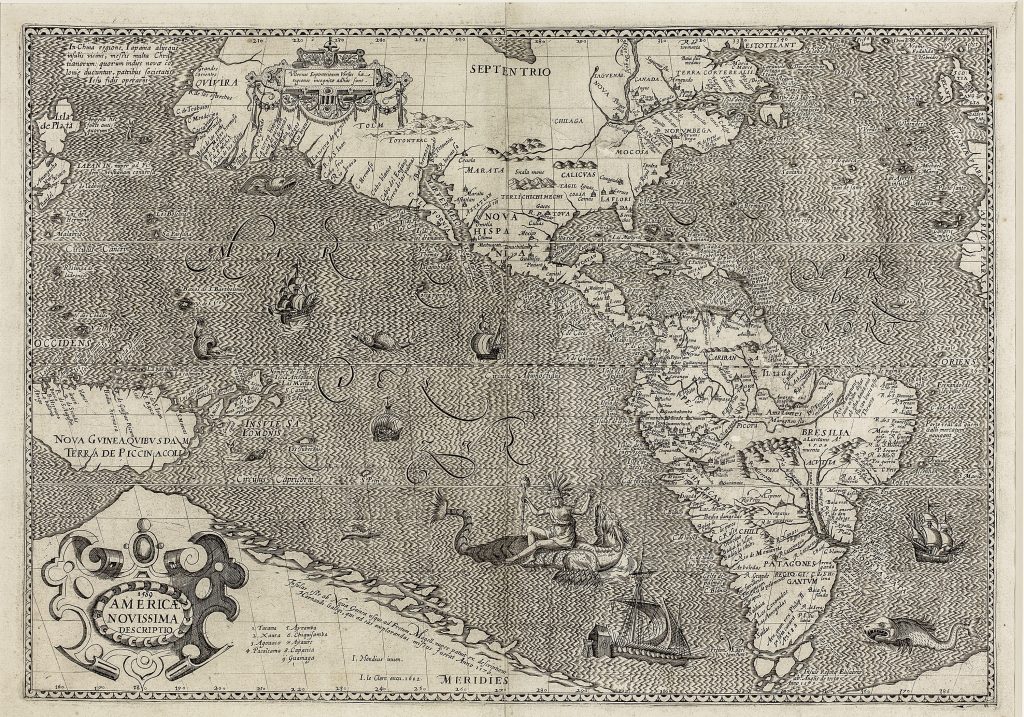
Americae Novissima Descriptio
Jodocus Hondius I was a Flemish engraver, instrument maker, and map publisher whose career moved between Ghent, London, and Amsterdam. After leaving Ghent during the religious turmoil of the 1580s, he worked in London, where he became familiar with English maritime circles and with information surrounding Sir Francis Drake’s circumnavigation. In 1593 he settled in Amsterdam, and in 1604 he acquired a large group of Gerard Mercator’s atlas plates. From 1606 he issued an expanded version of Mercator’s atlas, now generally known as the Mercator-Hondius atlas series.
This map of the Americas carries two important dates: 1589 in the cartouche, and the imprint I. Hondius inven. et I. le Clerc excu. 1602. This has led to debate about its creation and publication history. Philip Burden has argued that, although the map may have been engraved in 1589, its first known publication was by Jean Le Clerc in Paris in 1602. He notes that several geographical features — especially the chain of islands extending from the Strait of Magellan toward New Guinea — preserve an earlier phase of Hondius’s geography, predating his world maps of 1595 and 1598. The treatment of Japan and Greenland also reflects Hondius’s earlier London style. Günter Schilder gives greater weight to the map’s references to Sir Francis Drake as evidence for the 1589 engraving date. South of Cape Horn, Hondius shows the Insulae Reginae Elisabetae or Queen Elizabeth’s Islands, accompanied by the inscription Insulae Reginae Elisabetae ab Anglis detectae Anno 1579. This reference to Drake’s circumnavigation supports the view that Hondius prepared the plate in 1589, drawing on English voyage information available to him from his London years.
Taken together, Burden’s and Schilder’s readings suggest a two-stage history: the map was probably engraved by Hondius in 1589 and first published by Le Clerc in 1602. The map belongs to a group of six large maps engraved by Hondius — two world maps and four continental maps — and published by Jean Le Clerc in Paris between 1602 and 1605. It is therefore important not only as a map of the Americas, but as evidence of how English, Dutch, and French print networks circulated information about Drake, the Pacific, and the southern reaches of the New World. It presents the Americas within a global maritime context shaped by exploration, imperial rivalry, and the uncertain geography of the far south.
Within the collection, this map is closely connected with Hondius’s double-hemisphere world map Orbis terrae novissima descriptio (199), which similarly incorporates Drake-related southern geography, and Hondius’s portrait of Drake (212). It also relates to the late sixteenth-century sequence of Americas and Pacific maps by Frans Hogenberg (130), Giovanni Battista Mazza (219), and Abraham Ortelius (221), where the Americas, the Pacific, and the southern continent are increasingly treated as connected parts of global geography.
Hondius I, Jodocus (1563–1612)
Separate publication. Paris: Jean Le Clerc, 1602
1602, first
Copperplate engraving
131
R1 Extremely rare - occasionally seen on the market