
Orbem maritimum seu omnium marium totius orbis terrarum navigationibus (ID 50A Courtiers and Cannibals)
Johannes Janssonius was born into a family of publishers and booksellers, gaining expertise in book printing from a young age.
In 1612, he married Elisabeth Hondius, the daughter of the renowned mapmaker Jodocus Hondius I (View Record (#80), View Record (#212), View Record (#253), View Record (#272)) and his wife, Colette (View Record (#113)).
Six years later, Janssonius established his own cartographic shop next door to his competitor, Willem Blaeu (View Record (#9), View Record (#76), View Record (#108), View Record (#121), View Record (#351), View Record (#358)).
In 1630, Janssonius partnered with his brother-in-law, Henricus Hondius (View Record (#18), View Record (#82), View Record (#114), View Record (#123), View Record (#126),
View Record (#378)) to release a supplement to the Mercator-Hondius Atlas titled ^Atlantis majoris
appendix, sive pars altera,which gradually expanded over the years.
In 1638, the atlas was renamedAtlas Novusand expanded to three volumes.
A fourth volume followed in 1646, and in 1650, a fifth was added, titled in LatinAtlantis majoris quinta pars, orbem maritimum.
This volume was divided into two partsOrbem Maritimum(focused on sea charts) andOrbis antiquus^ (dedicated to ancient geography).
The first part included a titlepage engraved by Daniel van Bremden.
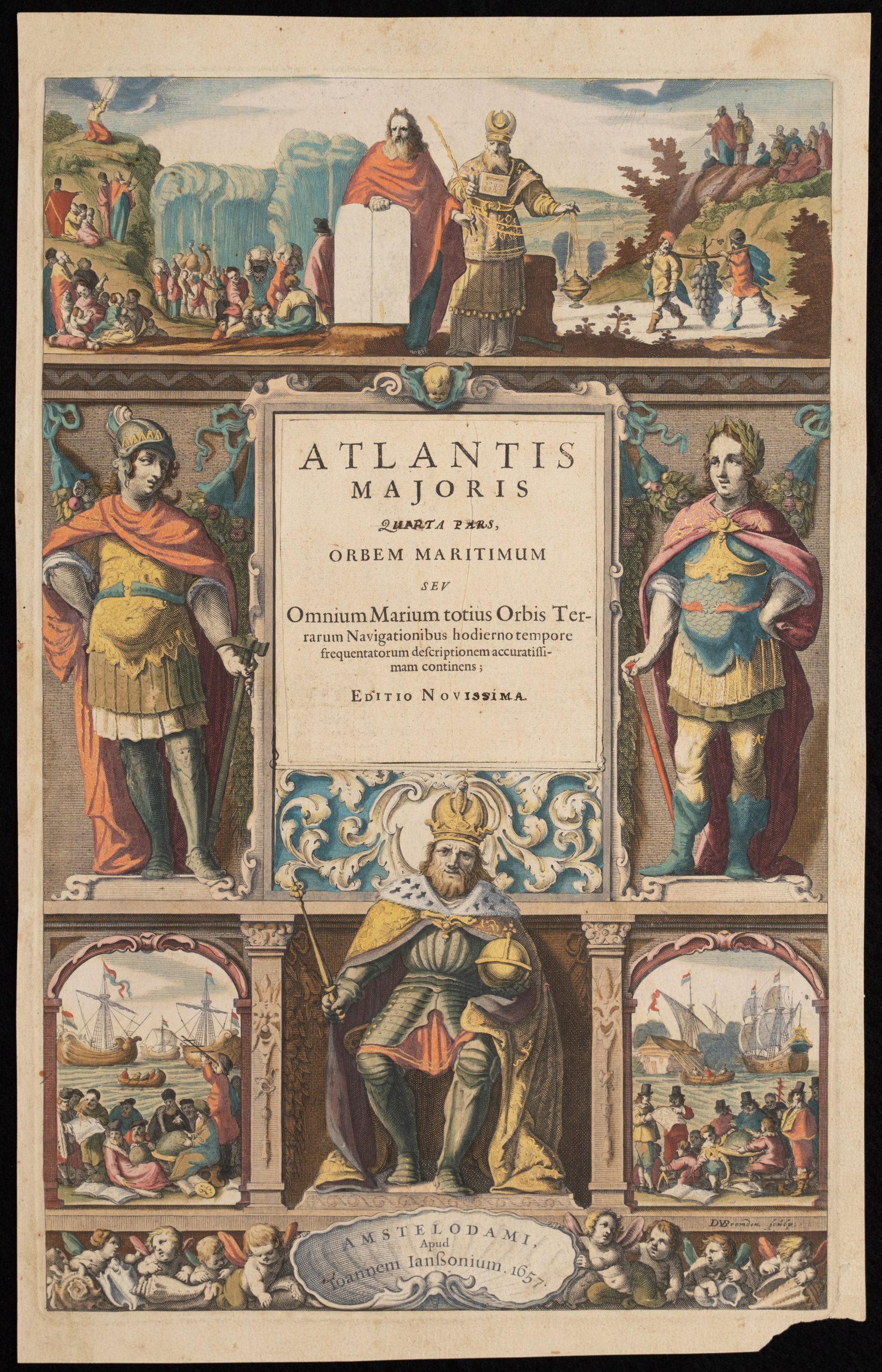
The title page discussed here is from the third edition, dated 1657.
Although marked Quarta, it belongs to Volume 5.
At the top of the page are scenes from the Old Testament.
Central to these is Moses, holding the stone tablets inscribed with the Ten Commandments, with Aaron, the high priest, standing beside him in ceremonial attire.
In the background, a vignette depicts the parting of the Red Sea, symbolising divine intervention and guidance.
To the right, Moses and the Israelites are shown gazing upon the Promised Land of Canaan.
Below, a vivid illustration of Numbers 13:23 portrays the scouts sent by Moses returning from Canaan, carrying a massive cluster of grapes on a pole—a symbol of the land’s abundance.
The central section of the composition is dominated by the title panel, flanked by two sturdy figures in Roman armour.
These figures convey strength, authority, and the enduring legacy of classical civilization.At the bottom sits a regal figure, likely the Holy Roman Emperor Ferdinand III, who reigned from 1637 to 1657.
His pose exudes authority, underscoring the political context of the atlas and its alignment with imperial power.
Flanking the emperor are two vignettes of naval activity, showing navigators charting routes.
These scenes highlight the maritime focus of the Atlas maritimus and the era’s emphasis on navigation and exploration.
This intricately designed title page reflects the atlas’s purpose: to serve as a comprehensive guide to geography and navigation while celebrating the religious, classical, and imperial foundations of knowledge.
Janssonius, Johannes (1588–1664)
Atlas novus, vol. 5, part 1.
Amsterdam: Johannes Janssonius, 1650
1657, Third
1652, Second
Copperplate engraving
50A Courtiers and Cannibals
R3 Uncommon - dealers can usually obtain a copy