
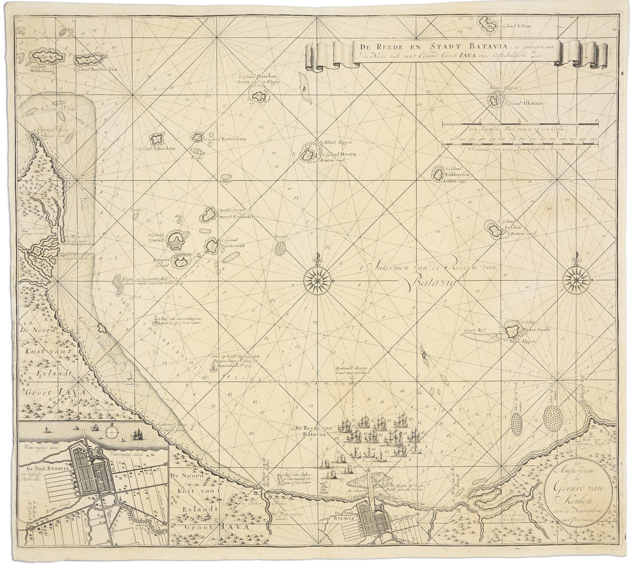
De reede en stadt Batavia, is geleegen aan de noord kust van 't eyland Groot Iava inde Oost Indische Zee
The Van Keulen family was renowned for their significant contributions to mapmaking and atlas publishing.
Their firm, “In de Gekroonde Lootsman” (In the Crowned Pilot), was established in 1678 by Johannes van Keulen I.
Just two years later, Johannes secured exclusive rights from the Dutch government to publish sea atlases and pilot guides.
That same year, he published De groote nieuwe vermeerderde zee atlas ofte water-werelt (Great New Enlarged Sea Atlas of the Water World), commonly referred to as Zee Atlas, which remained in production for fifty-four years with approximately thirty-four editions.
In 1681, van Keulen introduced the first two volumes of his pilot guide De Nieuwe lichtende Zee-fakkel (New Shining Sea Torch), widely known as Zee fakkel.
Over the next four years, three more volumes were added.
In 1704, Johannes’s son, Gerard van Keulen, took over the family business and expanded the atlases until his death in
1726.
Ownership then passed to Gerard’s son, Johannes II, who solidified the family’s legacy by
publishing the sixth and final volume of the Zee-Fakkel in 1753.
This new volume included previously restricted cartographic information on the East Indies, which the Dutch East India Company (VOC) had closely guarded to protect trade routes.
Merchants had to to return maps to the VOC after each voyage to preserve this secrecy, but the final volume made such information publicly accessible for the first time.
The fifth volume of the 1728 edition of the Zee-Fakkel included this detailed map Batavia (present day Batavia) and its surroundings.
It centres on Batavia Road, featuring soundings (in feet) along the coast, a narrow channel through a shallow reef leading to the harbour, and the expansive “Morass of Marshy Ground” opposite the harbour.
An inset in the lower left corner details the layout of Batavia and its district, while the main map extends to nearby islands and reefs.
Historical annotations mark significant maritime events, such as the grounding of the British and Dutch ships, like the “Poppies” in 1703 and the “Rygersdall” in 1705.
A key feature is fort on Onrust Island, a strategic location under Dutch colonial rule.
The map also highlights other islands in the Thousand Islands archipelago, underscoring Batavia's importance in Southeast Asia during the height of European colonial expansion.
Keulen, Gerard van (1678–1726)
De nieuwe groote lichtende Zee-fakkel,vol. 5, Amsterdam: Johannes van Keulen II, 1728
1728, First
Copperplate engraving
349
R1 Extremely rare - occasionally seen on the market