
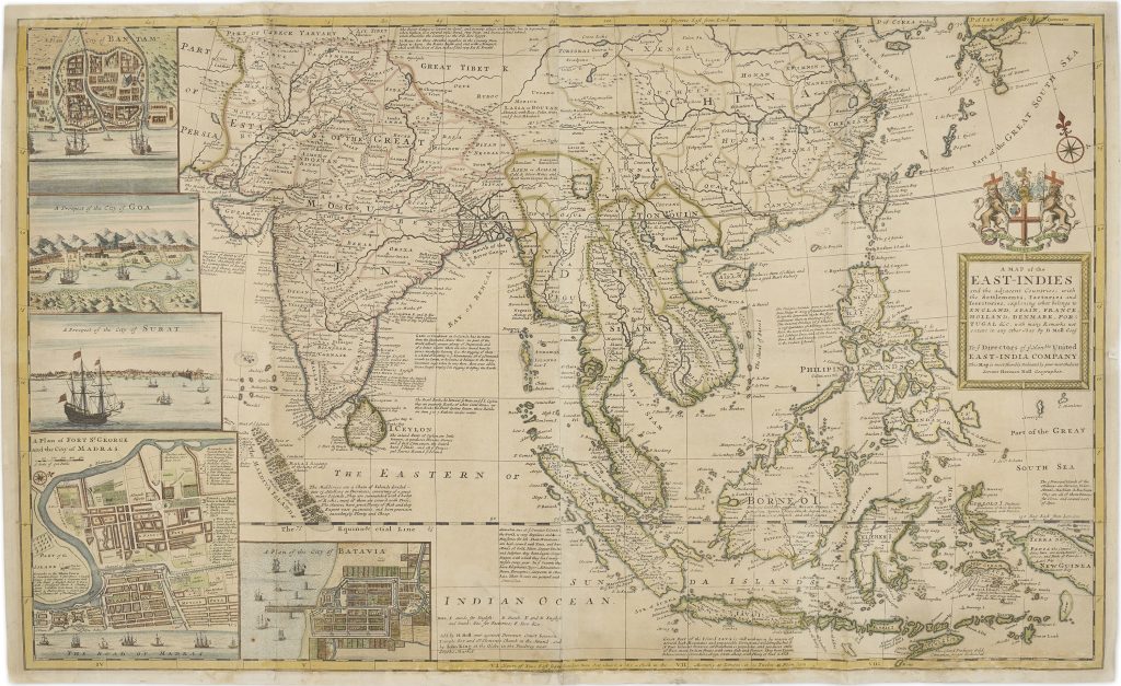
A map of the East Indies and the adjacent countries
Herman Moll was a German-born cartographer, engraver, and publisher who established his career in London in the late seventeenth century and became one of the city’s leading commercial mapmakers in the early eighteenth century.
His maps often combined geographical compilation with commercial and political commentary, reflecting Britain’s expanding interest in global navigation, trade, and colonial rivalry.
The fuller title wording records: A Map of the East-Indies and the adjacent Countries; with the Settlements, Factories and Territories, explaining what belongs to England, Spain, France, Holland, Denmark, Portugal &c with many remarks not extant in any other Map.
This large-format map was published in London by Herman Moll around 1715–20 and to the series of separately issued large atlas maps later gathered in Moll’s The World Described; or, A New and Correct Sett of Maps. It presents South and Southeast Asia as a commercial world shaped by ports, factories, settlements, and European competition.
The map extends from Persia, India, and Tibet across China, Japan, the Malay Peninsula, Siam, Cambodia, Tonkin, the Philippines, Borneo, Sumatra, Java, the Moluccas, New Guinea, and the northern edge of New Holland.
The title makes clear that Moll is not only mapping geography, but also explaining which European powers held influence in different parts of the region.
Along the left side are inset views and plans of Bantam, Goa, Surat, Fort St George and the city of Madras, and Batavia.
These places were associated with Dutch, Portuguese, English, and other European interests, making the map a visual guide to the commercial geography of the East Indies.
The map is also explicitly connected to the British East India Company.
It is dedicated to the Company’s directors, and the Company’s coat of arms appears prominently above the title cartouche.
In the long note at lower right, Moll traces the Company’s development from its royal charter of 1600 to its establishment in major Indian ports such as Surat, Bombay, and Calcutta.
He also refers to the Company’s trade in goods including gems, textiles, and tea, and to its political difficulties with Mughal authority under Emperor Aurangzeb.
The map therefore served not only as a geographical reference, but also as a statement of British commercial ambition in Asia.
New Holland appears at the lower right, joined to this wider East Indies geography through New Guinea, the Moluccas, Timor, and Java.
The coastline reflects the continuing influence of Dutch discoveries, but Moll’s map frames the region from a British commercial perspective.
Australia is not yet treated as a fully known continent; it appears as part of the maritime and trading world of Southeast Asia.
Within the collection, this map is closely connected with Moll’s smaller New Guinea, New Britain, and New Holland &c. (27), which focuses more directly on New Holland and the southwest Pacific.
It also relates to Pierre Mariette’s Carte Generale des Indes Orientales et des Isles Adiacentes (354), Johannes Loots’s Indian Ocean chart (4), Johannes van Keulen II’s chart of the western coast of Hollandia Nova (139), and earlier Southeast Asian maps by Sebastian Münster (5 and 96).
Together, these works show the changing European mapping of Southeast Asia from Renaissance geography and Dutch hydrography to early eighteenth-century British commercial cartography.
Moll, Herman (1654–1732)
Separate publication.
London: Herman Moll, 1710
c. 1720
Copperplate engraving
136
R3 Uncommon - dealers can usually obtain a copy