
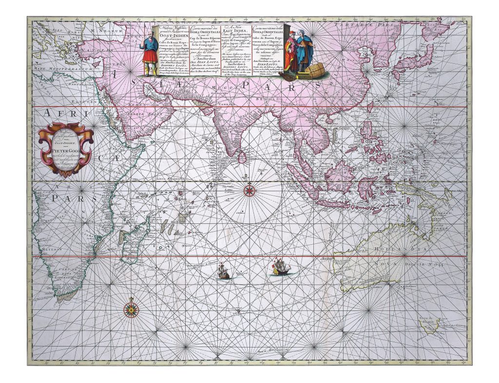
Nieuwe Wassende graade Paskaart van Oost-Indien streckende van Cabo de Bona Esperanca tot Terre de Compagnie van I.
Loots
Johannes Loots was an Amsterdam nautical instrument maker, chartmaker, and publisher.
Born in Amsterdam in 1665 or 1666, he was apprenticed to Hendrick Doncker in the 1680s and was admitted to the Amsterdam booksellers’ guild in 1693.
Working from In de Jonge Lootsman near the city’s other major nautical publishers, he issued sea charts and atlases for the competitive Amsterdam maritime market.
This large sea chart was issued by Loots around 1700.
It follows an earlier chart first published by Pieter Goos before 1660 and later associated with Jacob Robijn, before the plate passed to Loots.
The Loots imprint pasted over the original Goos imprint shows how valuable sea-chart plates could remain in use for decades, passing between Amsterdam publishers and being adapted for later issue.
The chart covers the Indian Ocean from the Cape of Good Hope in the west to Hollandia Nova and the western Pacific in the east.
It shows the route-world of VOC navigation: East Africa, Arabia, India, Ceylon, Southeast Asia, the East Indies, Japan, and the approaches to Batavia.
Rhumb lines, compass roses, latitude scales, coastal names, and island chains structure the chart for long-distance oceanic sailing.
The chart is especially revealing in its treatment of Australia and Dutch voyages in the region.
Simon Dewez notes that it is one of the few printed charts to show the track of the Batavia, wrecked on the Frederik de Houtman Abrolhos off the west coast of Australia just before daybreak on 4 June 1629.
It also records many early Dutch contacts with the Australian coast, including Dirk Hartog’s 1616 landfall, Frederik de Houtman’s 1619 discoveries, the Leeuwin’s contact in 1622, and Gerrit Frederiksz. de Witt’s voyage in 1628.
Pieter Nuyts’s 1627 discoveries in ’t Gulden Zeepaert are noted along the South Australian coast, while the 1623 voyage of Jan Carstensz. and Willem Joosten van Colster is reflected in the mapping of Cape York and Arnhem Land.
The chart also includes Abel Tasman’s first voyage of 1642–43, with Van Diemens Landt and Staten Landt shown in the southeast.
Within the collection, this chart is closely connected with Johannes van Loon’s Pacific chart showing Staten Lant and Van Diemens Lant (290), Johannes van Keulen II’s chart of the western coast of Hollandia Nova (139), Robert Dudley’s chart of the western and northern coasts of Australia (172), and Jan de Lat’s map of Nieu Holland (389).
Together, these works show how Dutch discoveries around Australia were incorporated into Indian Ocean, East Indies, and Pacific cartography before the continent’s eastern coast was fully known.
Loots, Johannes (1665–1726)
Amsterdam: Pieter Goos, before 1660
c. 1700
Copperplate engraving
4
R2 Very rare - one or two copies appear on the market