
World map
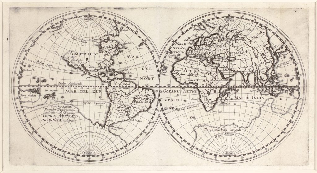
Hessel Gerritsz. was one of the leading Dutch cartographers of the early seventeenth century. Trained in the circle of Willem Jansz. Blaeu, he established an independent Amsterdam workshop and in 1617 was appointed the first exclusive mapmaker to the Dutch East India Company, or VOC. This small, untitled double-hemisphere world map belongs to the publication history of Gerritsz.’s 1612 work on Samoyed Land, Tatary, Arctic geography, and routes toward Asia. This example is the Latin issue, associated with Gerritsz.’s Latin reworking of the text, rather than the first Dutch issue represented elsewhere in the collection (99). The Latin publication context is recorded as Descriptio ac delineatio geographica detectionis freti, issued in 1612.
Like the Dutch issue, the map is notable for its prominent treatment of Pedro Fernandes de Quirós’s claimed discovery in the South Pacific. The southern continent carries the inscription — “Land recently discovered by Pedro Fernandes de Quirós, formerly celebrated under the name Terra Australis Incognita.” Quirós had sailed with Álvaro de Mendaña’s 1595–1596 expedition before leading his own 1605–1606 voyage in search of the southern continent. His claimed discovery, Austrialia del Espíritu Santo, is now understood as part of Vanuatu rather than the continental landmass he imagined. Like the Dutch issue, the map is notable for its prominent treatment of Pedro Fernandes de Quirós’s claimed discovery in the South Pacific. The southern continent carries the inscription Terra per Petrum Fernandez de Quir recens detecta, olim verò sub nomine Terrae Australis Incognitae celebrata — “Land recently discovered by Pedro Fernandes de Quirós, formerly celebrated under the name Terra Australis Incognita.” Quirós had sailed with Álvaro de Mendaña’s 1595–1596 expedition before leading his own 1605–1606 voyage in search of the southern continent. His claimed discovery, Austrialia del Espíritu Santo, is now understood as part of Vanuatu rather than the continental landmass he imagined.
The map therefore presents a world in which recent voyage reports are folded into inherited cosmographical expectations. Gerritsz. gives Quirós’s claim a global setting, placing the supposed discovery within the southern continent rather than treating it simply as an island encounter. This helped sustain the association between Quirós, the South Pacific, and the idea of a vast southern land. This Latin issue differs from the first Dutch issue (99) in its North American geography. In contrast to 99, it extends the Pacific coast of North America northward toward the Strait of Anian and marks N. Albion in California. These changes show that the issue is not simply a duplicate impression, but part of a developing publication sequence in which Gerritsz. adjusted geographical detail while retaining the broader Quirós and Terra Australis framework.
Within the collection, this map should be read directly alongside the Dutch issue (99), since the two examples show how Gerritsz.’s world map circulated in different textual settings in 1612. It also relates to the collection’s broader group of world maps concerned with the southern continent, including Oronce Fine’s double cordiform world map (88), the world map by Petrus Plancius from Jan Huygen van Linschoten’s Itinerario (71), Hendrick Doncker’s double-hemisphere world map (23), and Philipp Eckebrecht’s world map made for use with Johannes Kepler’s Tabulae Rudolphinae (125). These cross-references show how the southern continent remained a powerful organising idea in world cartography even as new reports from the Pacific began to complicate inherited geographical models.
Gerritsz., Hessel (1581–1632)
Beschryvinghe vander Samoyeden Landt in Tatierien, Amsterdam: Hessel Gerritsz., 1612
1612, second, Latin issue
Copperplate engraving
101
R2 Very rare - one or two copies appear on the market