
Mar del Zur
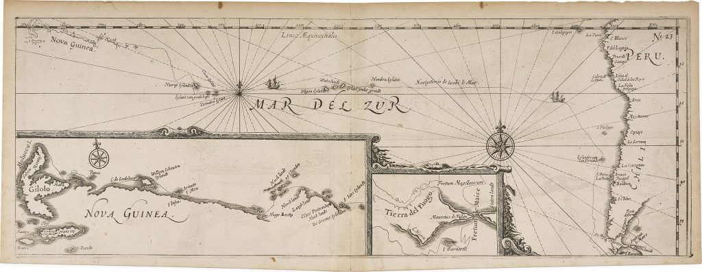
Joris van Spilbergen was a Dutch naval commander whose 1614–17 voyage around the world formed one of the major Dutch circumnavigations of the early seventeenth century. His account was published in Leiden by Nicolaes van Geelkercken in 1619 as Oost ende West-Indische Spiegel der 2 leste navigatien... Met de Australische navigatien. This plate, numbered 33, was included in the account and shows Jacob Le Maire’s and Willem Cornelisz. Schouten’s discovery of an alternative route into the Pacific Ocean. Their passage bypassed the Strait of Magellan by sailing through Le Maire Strait, east of Tierra del Fuego, and then rounding Cape Horn.
The map extends from New Guinea at left to Peru and Chile at right. Across the Pacific are islands associated with Le Maire’s voyage, including Hoornse Eylant, Verraders Eylant, Vliegen Eylant, Waterlandt, Cocos Eylant, Honden Eylant, and Sonder grondt. The west coast of South America is shown with coastal names from Peru southwards to Chile, while rhumb lines and compass roses organise the ocean as a navigable space.
Two inset charts connect the Pacific route to key discoveries at either end of the voyage. The lower-right inset shows the region around Tierra del Fuego, Le Maire Strait, Cape Horn, and Staten Land, marking the alternative passage into the Pacific discovered by Le Maire and Schouten in 1616. The larger lower-left inset shows the north coast of New Guinea and the islands around the Moluccas, linking the Pacific crossing to the Asian waters reached by Dutch voyagers.
Although published in Spilbergen’s account, the chart is especially concerned with Le Maire’s route and its consequences. Le Maire’s voyage, undertaken for the Australische Compagnie, challenged the Dutch East India Company’s control over the established passages to the East Indies by showing that ships could enter the Pacific south of Tierra del Fuego without using the Strait of Magellan. The chart therefore records both a geographical discovery and a commercial challenge to monopoly.
Spilbergen, Joris van (1568–1620)
Oost ende West-Indische Spiegel der 2 leste navigatien... Met de Australische navigatien, Leiden: Nicolaes van Geelkercken, 1619
1619, first
Copperplate engraving
406
R2 Very rare - one or two copies appear on the market