
Tijpus Freti Magellanici; quod Georgius Spilbergius cum Classe lustravit
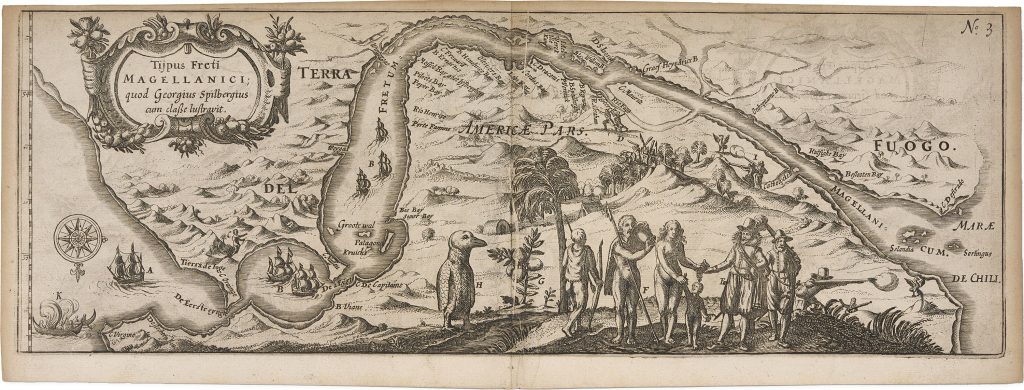
Joris van Spilbergen was a Dutch naval commander whose 1614–17 voyage around the world formed one of the major Dutch circumnavigations of the early seventeenth century. His account was published in Leiden by Nicolaes van Geelkercken in 1619 as Oost ende West-Indische Spiegel der 2 leste navigatien... Met de Australische navigatien. This plate, numbered 3, was included in the account and shows the Strait of Magellan as Spilbergen’s fleet passed through it in 1615.
The plate is both a map and a voyage image. It is oriented with south at the top and shows the fleet entering the strait from the Atlantic Ocean at left and moving toward the Pacific Ocean at right. Spilbergen’s passage was notably swift: he completed the transit in less than a month, faster than earlier circumnavigators who had attempted the route. The title records that Spilbergen traversed or surveyed the Strait of Magellan with his fleet. The lettered references on the plate are explained in the accompanying text of Spilbergen’s journal. They identify: A, the ship overtaken by mutinous sailors, which fled from the fleet; B, the remaining five ships entering the Strait; C, a person frequently seen on the south side of the Strait; D, an ambush in which Indigenous people armed with clubs attacked and killed members of the Dutch party; E, Indigenous people approaching the shore and communicating with the crew in an unfamiliar language; F, the offering of Spanish wine and other goods, which were received with apparent pleasure; G, red berries growing abundantly in the region; H, a penguin, representing the many penguins seen there; I, sailors shooting birds onshore; and K, the form of local canoes or skiffs.
The plate also records the natural environment encountered by Spilbergen and his crew. It shows the rugged mountainous terrain of Tierra del Fuego and the Chilean coast, sparse vegetation, native huts, canoes, red berries, birds, and a penguin. These details make the sheet more than a route map: it presents the strait as an observed environment, combining navigation, conflict, encounter, natural history, and ethnographic description. The plate is important within the collection because it belongs to the early printed geography of the far south. It shows the Strait of Magellan not only as a passage between the Atlantic and Pacific, but as a contested and inhabited zone at the edge of European knowledge. Its depiction of Terra del Fuego and Magellanica belongs to the same visual world in which the southern tip of South America was still closely associated with speculation about a larger southern continent.
Within the collection, this plate is closely connected with Spilbergen’s related Pacific chart, Mar del Zur (406), which follows the wider route across the Pacific and includes an inset of the Strait of Magellan and Cape Horn region. It also relates to Schouten and Le Maire material in the collection (16and 452), where the discovery of Le Maire Strait and Cape Horn offered an alternative route into the Pacific.
Spilbergen, Joris van (1568–1620)
Oost ende West-Indische Spiegel der 2 leste navigatien ... Met de Australische navigatien, Leiden: Nicolaes van Geelkercken, 1619
1619, first
Copperplate engraving
405