
A topographical plan of the settlements of New South Wales
Charles Grimes was a surveyor in early colonial New South Wales and later Surveyor-General of the colony. Matthew Flinders, already recognised for his coastal surveying and exploration, contributed hydrographic and topographical information from his work around the New South Wales coast. This separately published map was issued in London by Aaron Arrowsmith in 1799 and brings together colonial survey, coastal navigation, and metropolitan map publishing in one of the earliest detailed printed maps of the Sydney region.
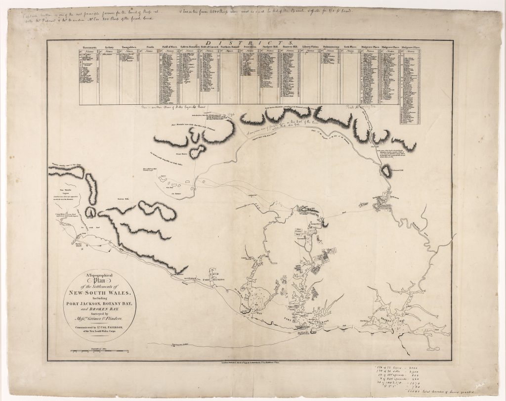
The map records the colonial settlements around Sydney a little more than a decade after the arrival of the First Fleet. Port Jackson, Botany Bay, Broken Bay, the Hawkesbury, Parramatta, and surrounding districts are shown in relation to roads, rivers, coastal forms, land grants, and named local features. The table of districts across the upper part of the sheet lists settled areas and landholders, making the map both a geographical image and a record of early colonial land occupation. The exploratory routes include south-westward movements toward the Cow Pastures and Mount Hunter, the westward path taken by George Bass’s party from Mount Hunter toward the Blue Mountains, and the outward and return tracks associated with Bass and Flinders’s 1796 voyage in the Tom Thumb to the “Canoe River, ” now generally identified with the outlet of Lake Illawarra. These routes show how early settlement mapping was already tied to coastal reconnaissance, overland exploration, and the search for usable land beyond the immediate Sydney districts.
This copy includes manuscript annotations in the margins and map area, including concerning land grants and acreages. These additions give the map a further documentary value, showing how printed maps of the colony could be used, updated, and interpreted by later owners or officials.
Within the collection, this map is closely connected with other works concerned with the mapping and representation of early colonial Australia, especially John Oxley’s interior map of New South Wales (166), Thomas Livingstone Mitchell’s map of southeastern Australia and his expedition routes (179), Robert Dixon’s map of appropriated lands in New South Wales (267), and Allan Cunningham’s exploration map (170). Together, these works trace the development of colonial mapping from the first settlement districts around Sydney to inland exploration, road-making, surveyed counties, and named land occupation.
Grimes, Charles (1772–1858)
Separate publication. London, Aaron Arrowsmith, 12 March 1799
1799, first
Copperplate engraving
165
R2 Very rare - one or two copies appear on the market