
Page from Allan Cunningham’s original diary with manuscript map
Allan Cunningham was an English botanist and explorer whose Australian fieldwork linked natural history, coastal survey, and inland exploration in the early nineteenth century. His scientific career began at the Royal Botanic Gardens, Kew, under the patronage of Sir Joseph Banks, who selected him as an overseas botanical collector. After an initial assignment in Brazil, Cunningham arrived in Australia in December 1816. He soon became closely involved in both inland and coastal exploration, joining John Oxley’s 1817 expedition to the Lachlan and Macquarie Rivers before accompanying Phillip Parker King’s Australian coastal surveys between 1817 and 1822.
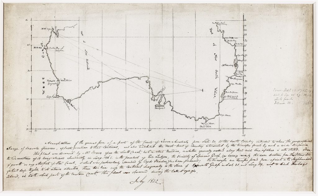
Cunningham sailed with King aboard HMS Mermaid and later HMS Bathurst, collecting botanical specimens while King completed surveys of the northern and western coasts of Australia, including regions not fully charted by Flinders or Baudin. His fieldwork during these voyages placed botanical observation within the practical work of coastal survey, route-making, and imperial geography. This original manuscript page from Cunningham’s diary, dated 1822, contains a hand-drawn outline map of part of the Australian coast with an explanatory note beneath. The map was made to show the observed and inferred geographical range of Scaevola spinescens, a native Australian fan-flower. Cunningham uses a sparse coastal outline, latitude and longitude lines, and diagonal triangular constructions to relate known plant sightings to large areas of the still poorly understood interior. The manuscript note explains that Scaevola spinescens had been found on the south coast by Robert Brown during Matthew Flinders’s Investigator voyage, and later observed at points on the western coast during more recent surveying voyages. Cunningham then reasons from these scattered observations to propose a broad possible distribution across Terra Australis. The result is not simply a botanical note, but an early attempt to use plant geography as a way of thinking about the shape, scale, and environmental character of the continent.
The map refers to coastal points including Port Jackson, Spencer Gulf, Exmouth Gulf, Dirk Hartog Island, Swan River, and Rottnest Island. These locations connect Cunningham’s botanical reasoning with the wider history of Australian coastal exploration, particularly Flinders’s earlier surveys and King’s voyages of 1817–22. Rather than mapping political boundaries, settlements, or routes, Cunningham used the map to visualise the possible distribution of a plant species across a vast and largely unknown interior. The page is significant because it shows botanical science being translated into cartographic form. Cunningham brought together field observation, earlier voyage records, coastal cartography, and ecological inference to produce an early example of scientific mapping in Australia. The manuscript therefore records a moment when botany, exploration, and geography were closely entwined in the effort to understand the continent. Transcription of the text beneath the map:
"A rough outline of the general form of a part of the coasts of Terra Australis from Lat. 20, to the South Coast, intended to show the geographical range of Scaevola spinescens, a plant peculiar to that Continent, and also to exhibit the vast tract of country intersected by the triangles formed by such a wide dispersion. This plant was discovered by Mr Brown upon the South Coast, but in what Meridian, or whether generally scattered along that arid line of shore is not stated. From the Circumstance of its being observed abundantly, in Long. 146E in the parallel of Port Jackson, the Vicinity of Spencer’s Gulf (as being nearly the same distance from the Interior Site of growth as any other part of the Coast, & which was particularly examined by Capt. Flinders,) has been presumed: the triangles are therefore formed from a point in the Neighbourhood of that deep Bight to its interior situation thence their lines crop the Continent diagonally to the shores of Exmouth Gulf in Lat. 21 and Long. 114 and to Dirk Hartogs Island, at both which parts of the Western Coast this plant was observed during the late voyages."
Cunningham, Allan (1791–1839)
Original manuscript, July 1822
1822
Manuscript map and text in ink on paper
170
Only copy