
A chart of the Indian Ocean, and of part of the South Sea
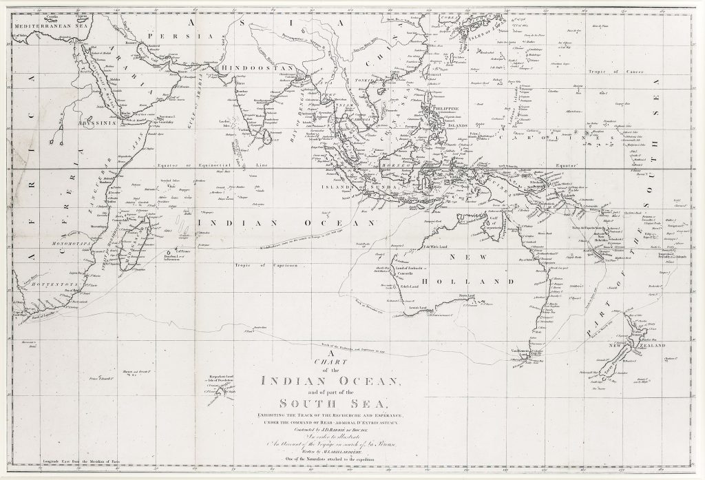
Jean-Denis Barbié du Bocage was a French geographer and cartographer who prepared this chart of the Indian Ocean and part of the South Sea. It was engraved by John Russell, for the English edition of Jacques-Julien Houtou de Labillardière’s An Account of a Voyage in Search of La Pérouse, published by J. Debrett in London in 1800.
The chart covers the Indian Ocean, Southeast Asia, New Holland, Van Diemen’s Land, New Zealand, and part of the South Pacific. Its main purpose is to show the track of the French ships Recherche and Espérance, commanded by Rear Admiral Antoine Raymond Joseph de Bruni d’Entrecasteaux during the expedition sent to search for Jean-François de Galaup, comte de La Pérouse. The plotted route crosses the Indian Ocean and passes the southern coast of Australia, the north coast of New Zealand, and the Spice Islands. The expedition sailed from France in 1791 after La Pérouse’s ships had disappeared following their departure from Botany Bay in 1788. Although d’Entrecasteaux did not find La Pérouse, the voyage produced important geographical and scientific information. The ships visited southwest Australia, Van Diemen’s Land, New Zealand, and the East Indies, while Labillardière and other naturalists collected botanical, zoological, geological, and ethnographic material.
The chart places Australia within a broad Indo-Pacific frame. It shows New Holland before the full publication of Matthew Flinders’s work, with the southern coast still partly incomplete and Van Diemen’s Land shown in relation to the discoveries and uncertainties of the period. The voyage track makes the map a record of movement as much as a regional chart, linking Australia, the Indian Ocean, Southeast Asia, and the Pacific through the search for La Pérouse.
Within the collection, this chart is closely connected with Jean Baptiste Poirson’s Carte réduite de la mer des Indes et de la partie occidentale du Grand Océan (31), which also places New Holland within the maritime geography of the Indian Ocean and western Pacific. It also relates to Johann Matthias Christoph Reinecke’s General Charte von Australien (26), which incorporates new voyage information into a German map of Australia and the Pacific, and to Thomas Pennant’s Map for Mr Pennants Outline of the Globe (178), which records the transitional moment before Bass Strait was fully fixed in print.
Barbié du Bocage, Jean-Denis (1760–1825)
Labillardière, Jacques-Julien Houtou de, An Account of a Voyage in Search of La Perouse, London: J. Debrett, 1800
1800, first English issue
Copperplate engraving
163
R2 Very rare - one or two copies appear on the market