
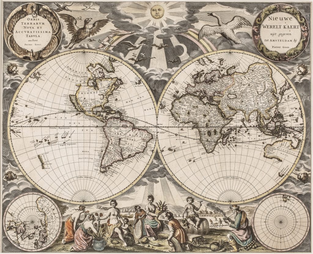
Orbis terrarum nova et accuratissima tabula=Nieuwe Werelt Kaert uyt gegeven tot
Pieter Goos was an Amsterdam chartmaker and publisher whose work belongs to the commercial Dutch sea-atlas tradition of the later seventeenth century. The son of the engraver and mapmaker Abraham Goos, he built a successful publishing business around pilot books, sea charts, and maritime atlases. His Zee-Atlas ofte Water-Wereld, first published in Amsterdam in 1666, presented Dutch nautical geography in a large and visually ambitious format.
This double-hemisphere world map was issued in the 1666 Zee-Atlas and carries titles in both Latin and Dutch: Orbis terrarum nova et accuratissima tabula and Nieuwe Werelt Kaert. Although included in a sea atlas, the map functions as a general world map, bringing together terrestrial geography, maritime knowledge, polar insets, and decorative allegory. The map reflects the state of European geographical knowledge in the mid-seventeenth century. Hollandia Nova appears in the eastern hemisphere, with the west and north coasts of Australia derived from Dutch discoveries and with the southern part of Tasmania reflecting Abel Tasman’s voyage. The north-western part of North America remains unresolved, while California is shown as an island, a persistent seventeenth-century cartographic error.
The lower corners contain polar insets, with the northern polar regions at left and the southern polar projection at right. Around the hemispheres, Goos adds a rich decorative programme: the sun and moon appear among clouds at the top, birds fly across the sky, and wind heads blow from the margins. At the lower centre, allegorical figures represent the seasons and abundance, giving the map a cosmographical and moralised frame as well as a geographical one.
Within the collection, this world map is closely connected with other Dutch world maps that combine maritime geography with decorative and cosmographical imagery, including Hendrick Doncker’s double-hemisphere world map (23). It also relates to Goos’s sea charts of the Pacific and East Indies (466and 307), which show the practical nautical geography behind the broader world image. For the southern hemisphere, it can be compared with works concerned with Terra Australis and early Dutch discoveries in Australia, including Philipp Eckebrecht’s world map made for use with Johannes Kepler’s Tabulae Rudolphinae (125).
Goos, Pieter (c. 1616–1675)
De Zee-Atlas ofte Water-Wereld, Amsterdam: Pieter Goos, 1666
1666, first
Copperplate engraving
115
R2 Very rare - one or two copies appear on the market