
Orbis terrarum typus de integro in plurimis emendatus, auctus, et icunculis illustratus
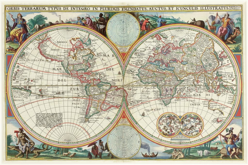
Nicolaes Visscher I was an Amsterdam engraver, mapmaker, and publisher who continued the Visscher family business after the death of his father, Claes Jansz. Visscher, in 1652. The Visscher firm was closely associated with the Dutch market for wall maps, atlas maps, Bible maps, and separately issued prints, and its plates were often revised, reissued, and adapted across several decades. This double-hemisphere world map is a later issue of the map first published in 1650 (25) for inclusion in editions of the Dutch Statenbijbel. The present example corresponds to the 1657 issue, printed in Amsterdam by Paulus Aertsz. van Ravesteyn.
The map belongs to a broader context of Dutch Bible cartography. The Statenbijbel itself was first published in 1637, following a state-sponsored translation of the Bible directly from the original Hebrew and Greek texts, and Van Ravesteyn’s Amsterdam press held the privilege for printing it through much of the mid-seventeenth century. As with the earlier issue (25), Simon Dewez regarded this map as a reworking of the 1614 world map by Claes Jansz. Visscher. Faint traces of the original plate can still be discerned, including the lettering Tierra del Fuego beneath South America and the coastline of Magellanica where it meets the southern coast of New Guinea.
Cartographically, the map captures a world in transition. It incorporates the results of Abel Tasman’s first voyage of 1642–1643, showing Tasmania as A. Van Diemen’s Landt, but omits the northern coastline of Australia charted during his second voyage in 1644, as well as New Zealand. The 1660 second state would later update this geography by adding the coastline of New Zealand. Earlier Dutch encounters with Australia are also shown, including Dirk Hartog’s 1616 landfall, Frederik de Houtman and Jacob d’Edel’s 1619 voyage near present-day Perth, the charting of the south-western coast by the Leeuwin in 1622, Jan Carstensz.’s 1623 exploration of Cape York Peninsula, Pieter Nuyts’s southern coastal survey in 1627, and Gerrit Frederiksz. de Witt’s grounding in 1628. Willem Jansz.’s 1606 landfall on Cape York Peninsula is not shown.
The map’s decorative programme places global geography within a wider cosmographical framework. Personifications of the four continents occupy the corners; two central diagrams contrast the Copernican and Ptolemaic systems; celestial hemispheres appear in the south-eastern quadrant; and an inscription in the south-western quadrant recounts the voyages of Christopher Columbus, Amerigo Vespucci, and the early circumnavigators of the globe.
Visscher I, Nicolaes (1618–1679)
Biblia (Statenbijbel), Amsterdam: Paulus Aertsz van Ravesteyn, 1650
1657
1660, second, includes the coastline of New Zealand
Copperplate engraving
93