
Insculptum est per Johannem Schnitzer de Armszheim / Ptolemaic world map
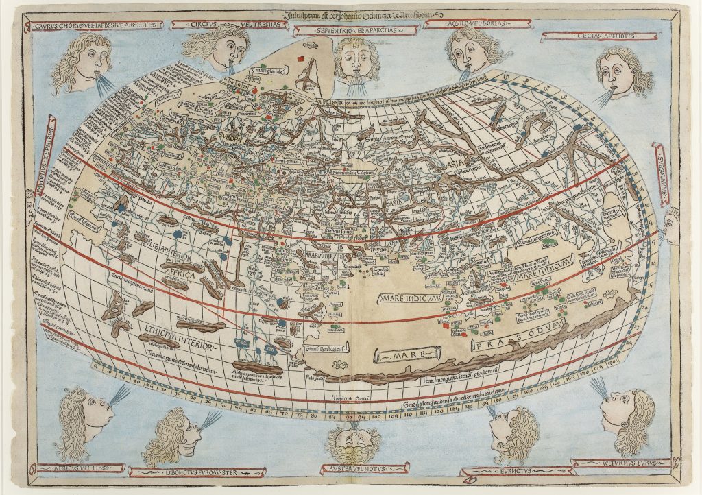
Johannes Schnitzer of Armsheim was the woodcutter responsible for the world map in the Ulm edition of Claudius Ptolemy’s Cosmographia. The inscription above the map, Insculptum est per Johannem Schnitzer de Armszheim, identifies him as its cutter. The map first appeared in Lienhart Holle’s Ulm edition of 1482, edited by Nicolaus Germanus, and this example belongs to Johann Reger’s 1486 second Ulm edition, which reused the original woodblocks.
The map presents the inhabited world according to the Ptolemaic geographical tradition. It uses Ptolemy’s second, or “cloak, ” projection, with curved lines of latitude and longitude forming a mathematical framework for the known world. Europe, North Africa, and Asia extend from the Fortunate Islands in the west to Serica and Cattigara in the east, while the equator and tropics are marked in red. The inscription Terra incognita secundum Ptolemæum acknowledges territory unknown according to Ptolemy. One of the map’s most striking features is its enclosed Indian Ocean, or Mare Indicum, reflecting the classical belief that the ocean was landlocked by southern Africa and eastern Asia. This older geographical structure is especially significant because the 1486 edition appeared only two years before Bartolomeu Dias rounded the Cape of Good Hope. The map therefore stands at the threshold between inherited Ptolemaic geography and the rapid revision of the world image through Portuguese oceanic navigation.
The map also includes Taprobana, the Sinus Magnus, the Sinus Gangeticus, the Nile rising from the Montes Lunae, and the east-flowing Niger system of classical geography. Twelve named wind heads surround the map, placing the world within a wider cosmographical order of direction, climate, and natural philosophy.
Within the collection, this map is closely connected with Hartmann Schedel’s world map from the Nuremberg Chronicle (127), which also preserves a late medieval and Ptolemaic world picture in early print. It also provides an important comparison with Gregor Reisch’s Typus universalis terrae (103), where the printed world begins to be reorganised through newer geographical divisions,
Schnitzer, Johannes, of Armsheim (fl. 1482)
Ptolemy, Claudius, Cosmographia, edited by Nicolaus Germanus, Ulm: Lienhart Holle, 1482
1486, second Ulm edition
Woodcut
92
R1 Extremely rare - occasionally seen on the market