
Totius orbis cogniti universalis descriptio
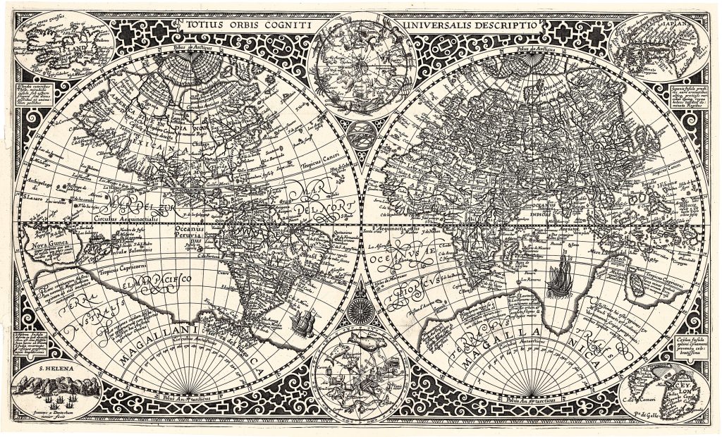
Paulus Merula was a Dutch scholar, historian, geographer, and librarian at Leiden University. In 1605, two years before his death, he published his Cosmographia generalis, in Leiden, with this world map, engraved by Jan van Doetecum. The map was based on an earlier version by Jan's father, Baptista van Doetecum, for Petrus Plancius in 1590, but it included significant updates.
The map presents the world in two hemispheres, surrounded by decorative strapwork, inset island maps, and two celestial hemispheres. The corner maps show Iceland, Japan, Saint Helena, and Ceylon: islands that mattered to navigation, trade, and geographical learning. The celestial insets connect terrestrial geography with the wider cosmographical interests of the period. In the north, the map reflects the influence of Gerard Mercator’s polar geography, showing four large Arctic islands and a possible passage between the Atlantic and Pacific by way of the Strait of Anian. North America includes California and Quivira, names associated with Spanish exploration and legends of rich lands in the interior. The map also includes annotations on Christopher Columbus’s 1492 discovery of America and on the still unknown northern parts of the continent. These details place the Americas within a wider geography of discovery, northern passage speculation, and routes to Asia.
In the south, a vast southern landmass appears under names including Magallanica, Terra Australis, and Terra Magallanica. This southern continent predates the voyage of Jacob Le Maire and Willem Cornelisz. Schouten, which would later show that Tierra del Fuego was not joined to a great southern land. The map also preserves inherited southern-continent labels, including Beach, south of Java, drawn from European readings of Marco Polo. New Guinea appears large and separate, but the geography of Australia and the southwest Pacific remains unknown. The result is a world map poised between navigational ambition and inherited speculation. The oceans are increasingly traversed, but the Arctic and far south remain zones of uncertainty, filled with possible passages, conjectural lands, and older geographical names..
Within the collection, this map is closely connected with Pieter van den Keere’s world map (109), another Dutch world map shaped by Mercatorian geography and southern-continent ideas. It also relates to Sebastian Münster’s later world map (393), Oronce Fine’s double cordiform world map (88), and Johannes Metellus’s Chica sive Patagonica et Australis Terra (226) all of which present different versions of Terra Australis.
Merula, Paulus (1558–1607)
Cosmographiae generalis, Leiden: Ex officina Plantiniana Raphelengij, 1605
1605, first
Copperplate engraving
59
R2 Very rare - one or two copies appear on the market