
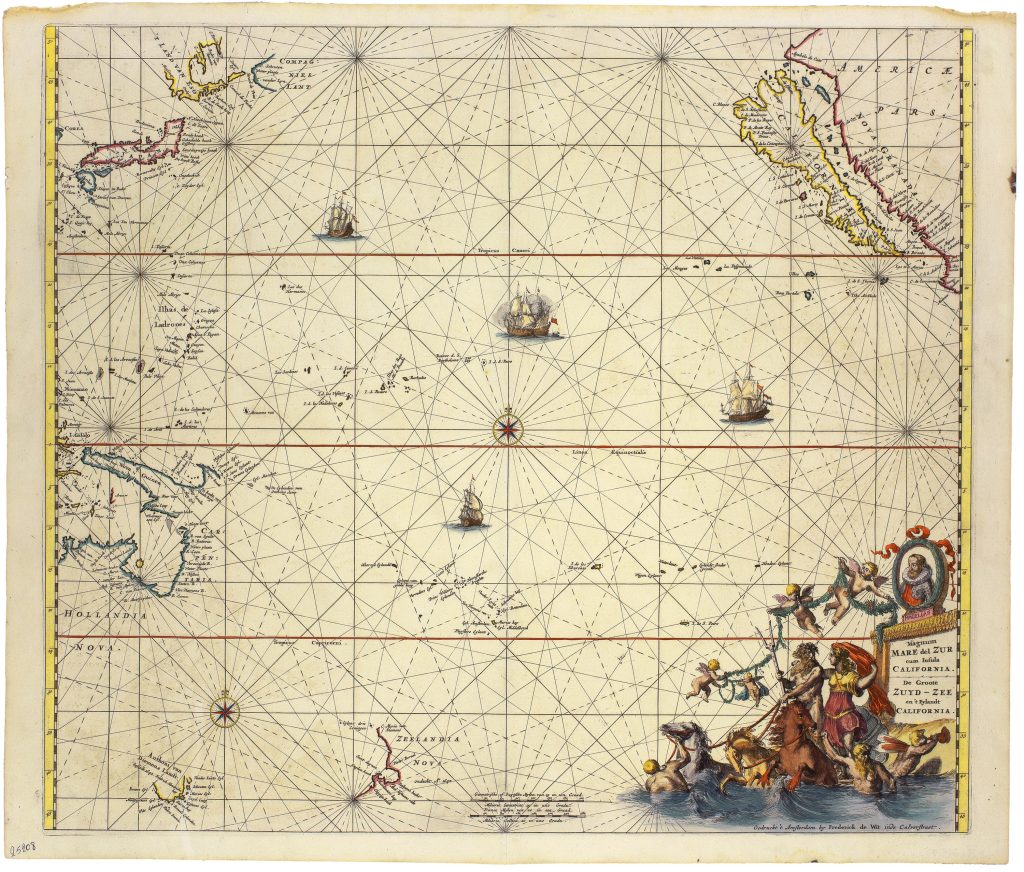
Magnum Mare del Zur cum insula California / de Groote Zuyd-Zee en't Eylandt California
Frederik de Wit was a Dutch engraver, mapmaker, and publisher who became one of the leading figures of the Amsterdam map trade in the second half of the seventeenth century. After establishing his own publishing house in 1648 under the sign De Drie Crabben (The Three Crabs), he adopted the name Witte Pascaert (The White Chart) in 1655. From his premises on the Kalverstraat he produced wall maps, atlases, sea charts, and town plans distinguished by their elegant engraving, decorative richness, and high-quality colouring. His works remained influential well into the eighteenth century and were later acquired and reissued by the firm of Covens & Mortier.
This chart of the Pacific Ocean was first published in Orbis maritimus ofte zee atlas in 1675. It presents the Pacific as a vast maritime theatre linking Asia, the Americas, and the newly charted coasts of Australia and New Zealand. California is shown as an island, while the coastlines of Australia and New Zealand reflect information from Abel Tasman’s voyages of 1642–1643 and 1644. The chart also incorporates Dutch knowledge from Willem Jansz.’s 1606 voyage along the western coast of Cape York Peninsula and the southern coast of New Guinea. The chart’s follows the influential Pacific prototype first developed by Johannes van Loon in 1661 and subsequently adapted by Pieter Goos (1666), Hendrick Doncker (1669), John Seller (1670). Its decorative programme reinforces the maritime theme: Ferdinand Magellan appears in the title cartouche, Neptune and sea creatures animate the oceanic setting, and four galleons traverse the sea.
This is the first state, published by Frederik de Wit in 1675. Later states were issued by Louis Renard in 1715 and the Ottens firm in 1745, showing the long afterlife of De Wit’s Pacific chart in the Amsterdam map trade.
Within the collection, this chart is closely connected with De Wit's world maps (128and 207), which incorporate many of the same Dutch discoveries, and his map of the East Indies (470), which provides greater regional detail for Southeast Asia and the Indonesian archipelago.
Wit, Frederik de (c. 1629/30–1706)
Orbis maritimus ofte zee atlas Amsterdam: Frederick de Wit, 1675
1675, first
1715, second; 1745, third
Copperplate engraving
42