
Eastern Southern Hemisphere — set of six globe gores
Vincenzo Coronelli was a Franciscan friar, mathematician, cosmographer, and mapmaker whose work stands at the centre of late seventeenth-century Venetian cartography. After entering the Franciscan Order as a young man, he expanded his studies from theology to mathematics, astronomy, geography, and engraving. In 1680 he founded the Accademia Cosmografica degli Argonauti, an early geographical society with an international membership of scholars, patrons, and collectors.
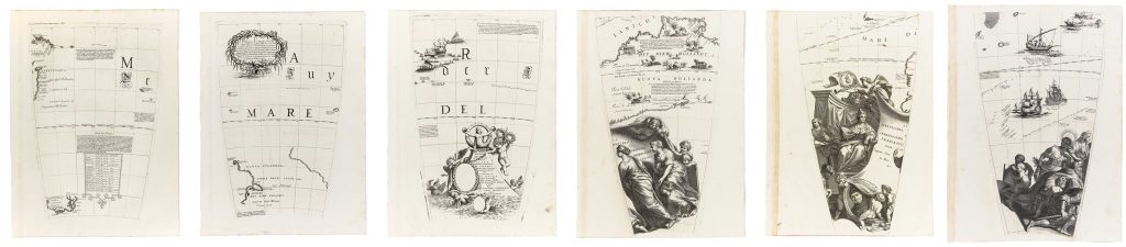
In 1681, Coronelli was invited to Paris by Louis XIV to construct two large manuscript globes, one terrestrial and one celestial, each more than four metres in diameter. Completed in 1683, the globes combined current geographical knowledge with elaborate allegorical and decorative programmes. After returning to Venice in 1684, Coronelli established a cartographic workshop at the Convent of Santa Maria Gloriosa dei Frari, where he produced globes, maps, and atlases, including the Atlante Veneto, the Isolario, the Libro dei Globi, and the Corso Geografico Universale. This set of six engraved globe gores belongs to Coronelli’s printed 42-inch terrestrial globe project, first issued in Venice in 1688. The same plates, or closely related impressions from them, were later circulated in printed form for collectors and readers, including in issues associated with Coronelli’s Libro dei Globi, generally dated 1693 but probably printed and circulated in the later 1690s. Designed for a globe measuring approximately 110 cm in diameter, the gores depict the eastern sector of the southern world, extending from southern and eastern Africa across the Indian Ocean toward the western coasts of New Holland. The land is labelled in Dutch as Het Niew Hollandt and in Italian Nuova Hollanda linking this group directly with the separately catalogued Het Niew Hollandt gore (66).
The sheets combine geographical, navigational, and decorative information. Southern Africa, Madagascar, and neighbouring islands are shown together with sea routes, coastal place names, and inscriptions, while the Indian Ocean is structured by island groups and maritime space rather than dense inland detail. On the Australian side, the western coastline of New Holland reflects the cumulative results of seventeenth-century Dutch exploration, translated by Coronelli into a globe format that brought recent voyage knowledge into conversation with Italian cartographic practice. As globe gores, these sheets were designed to be cut and assembled onto a sphere rather than read as a conventional flat map. Their tapering form and converging meridians reflect the geometry of globe construction, while their ornament and inscriptions show Coronelli’s broader ambition to present the globe as a visual synthesis of geography, exploration, commerce, and learned commentary.
This set is closely connected with the related Het Niew Hollandt gore (66), which focuses more closely on Australia, and the South Pole cap (421), which presents Coronelli’s allegorical treatment of the southern polar region It also relates to the set of Asia globe gores (346), and the set of southern and equatorial globe gores (386). Together, these sheets show how Coronelli divided his printed terrestrial globe into separately engraved components, each combining geographical information, voyage history, textual commentary, and visual ornament for assembly onto a sphere.
Coronelli, Vincenzo (1650–1718)
Venice: 110 cm / 42-inch terrestrial globe, 1688
c. 1690, from the printed globe gore series / Libro dei Globi issue
Copperplate engraving
6
R1 Extremely rare - occasionally seen on the market