
Southern and equatorial regions - set of 9 globe gores
Vincenzo Coronelli was a Franciscan friar, mathematician, cosmographer, and mapmaker whose work stands at the centre of late seventeenth-century Venetian cartography. After entering the Franciscan Order as a young man, he expanded his studies from theology to mathematics, astronomy, geography, and engraving. In 1680 he founded the Accademia Cosmografica degli Argonauti (Cosmographic Academy of the Argonauts), an early geographical society with an international membership of scholars, patrons, and collectors.
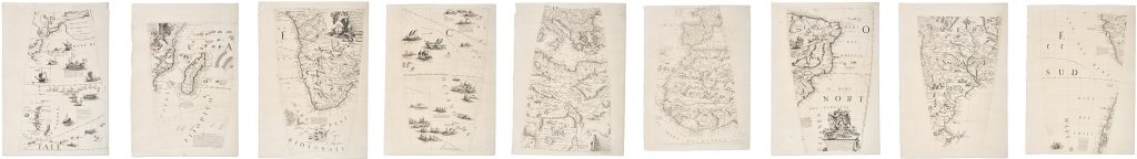
In 1681, Coronelli was invited to Paris by Louis XIV to construct two large manuscript globes, one terrestrial and one celestial, each more than four metres in diameter. Completed in 1683, the globes combined current geographical knowledge with elaborate allegorical and decorative programmes. After returning to Venice in 1684, Coronelli established a cartographic workshop at the Convent of Santa Maria Gloriosa dei Frari, where he produced globes, maps, and atlases, including the Atlante Veneto, the Isolario, the Libro dei Globi, and the Corso Geografico Universale. This set of nine engraved globe gores belongs to Coronelli’s printed 42-inch terrestrial globe project, produced in Venice in the late 1680s. Designed for a globe measuring approximately 110 cm in diameter, the gores translate aspects of Coronelli’s monumental globe-making into printed form. The present group depicts a broad sweep of the southern and equatorial world, including Japan and the western Pacific, the South Pacific, South America, the Mediterranean, Africa, Madagascar, and the Indian Ocean.
The gores combine dense geographical information with decorative and ethnographic imagery. South America is represented through separate sections showing the west coast of Peru and Chile, the interior and southern regions including Paraguay and Patagonia, and the Atlantic coast of Brazil. Africa appears across several sheets, from the Mediterranean and North Africa to the Nile, central and southern Africa, the Cape region, east Africa, Madagascar, and the western Indian Ocean. The Pacific sheets include Japan, Terra de Iesso, island groups, shipping, sea creatures, and scenes of maritime encounter. Rather than functioning as a conventional flat map, these sheets were designed to be cut and assembled onto a globe. Their curved form, converging meridians, and interrupted geography reflect the technical requirements of globe construction. Viewed as separate sheets, however, they reveal the way Coronelli organised the world into zones of coastlines, routes, inscriptions, allegorical figures, ships, animals, and ethnographic scenes.
This set is closely connected with the set of six globe gores showing the eastern sector of the southern world (6), and Het Niew Hollandt gore (66), which focuses more closely on Australia. It also relates to Asia globe gores (346) and the South Pole cap (421). Together, these sheets show how Coronelli divided his printed globe into separately engraved components, combining geography, voyage history, maritime routes, ethnographic imagery, allegory, and learned commentary for assembly onto a sphere.
Coronelli, Vincenzo (1650–1718)
Venice: 110 cm / 42-inch terrestrial globe, 1688
1688, first
Copperplate engraving
386
R1 Extremely rare - occasionally seen on the market