
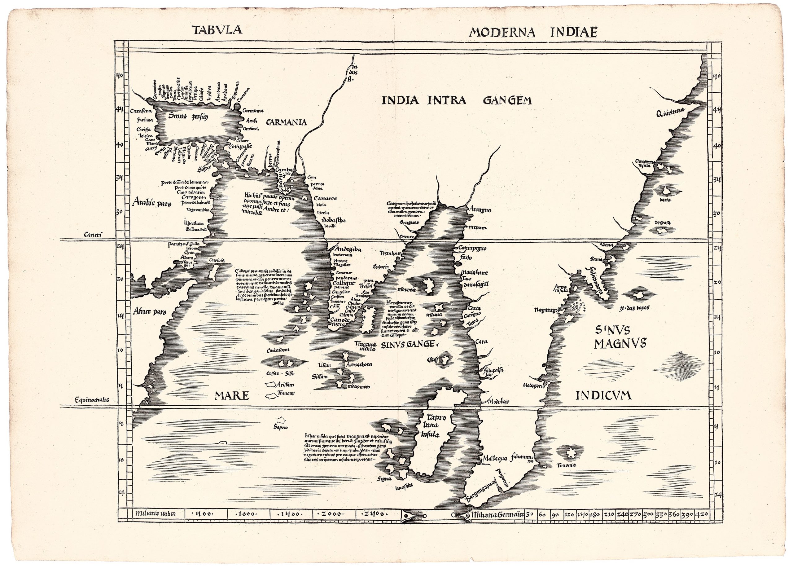
Tabula moderna Indiae
Martin Waldseemüller’s edition of Claudius Ptolemy’s Geographywas first published by Johann Schott in Strasbourg in 1513.
Waldseemüller, a German mapmaker and scholar, began his studies at the University of Freiburg in 1490, where he studied under Gregor Reisch (View Record (#103)).
He later moved to Saint-Dié in Lorraine, joining the Gymnasium Vosagense, a humanist circle established under the patronage of René II, Duke of Lorraine.
Around 1505, Waldseemüller partnered with Matthias Ringmann to publish a new edition of Geography.
After several delays, the edition was finally completed in 1513.
It featured twenty-seven Ptolemaic maps, alongside twenty modern maps that incorporated the most recent discoveries labelled either novaor moderna et nova.
The Ptolemaic maps, which formed the first part of the book, included a world map, ten maps of Europe, four of Africa, and twelve of Asia.
The modern maps, presented in the second section titled Supplementum, included this modern view of the Indian Ocean, India, Southeast Asia and adjacent regions.
It should be read alongside Waldseemüller’s Ptolemaic map of the same broad region (View Record (#61)).
Waldseemüller based this map largely on a manuscript world chart made around 1506 by the Genoese mapmaker Nicolo Caveri, now preserved in the Bibliothèque nationale de France.
By this time, Bartolomeu Dias had rounded the Cape of Good Hope in 1487, and European mapmakers were beginning to abandon Ptolemy’s enclosed Indian Ocean.
One such mapmaker was Henricus Martellus, who, around 1489, opened up the Indian Ocean by removing the southern landmass Ptolemy described as extending from the south of Africa to Asia.
The contrast with #~61 ~is striking.
Where the Ptolemaic map is filled with rivers, mountains, marvels, and inherited classical island lore, this modern map has a largely empty interior and a more open maritime geography.
Ptolemy’s cannibals, tailed peoples, magnetic islands, and Aurea Chersonesusdisappear.
In their place appears a huge unnamed peninsula extending into the Indian Ocean, with a large island labelled Taprobananear its western coast.
Waldseemüller closely followed Caveri’s coastal geography and adapted long inscriptions describing the commodities of major
Indian Ocean trade centres:
• Cambaia: ‘Here is to be found lac, fine stuffs of all kinds and
dried figs and grapes, and incense, and perfu Detail of Nicolo Caveri’s manuscript world chart, c. 1506 mes and amber and seed pearls which come from inland.’
• Calicut: ‘in it there are many
types of minerals and other kinds of merchandise which come from many parts: cinnamon, ginger, clove, sandalwood, and a bit of every spice: the region was discovered by the King of Portugal.’
• Morachim: ‘Here cinnamon grows and many kinds of spices, and here they fish for pearls and
seed-pearls, and the people of the island are idolaters and they trade with Calicut.’ • Taprobana: ‘In this island, which is quite large, gold is found, and there are sapphires, ginger, and spices of every other kind.
The inhabitants are devoted to idolatry, and trade with foreigners, taking merchandise abroad and bringing other things back.’ This modern map transforms the region from a classical landscape of marvels into a commercial geography shaped by Portuguese exploration and Indian Ocean trade.
Waldseemüller, Martin (1470–1520)
Geographiae opus nouissima traductione e Graecorum archetypis castigatissime pressum, Strasbourg: Johann Schott, 1513
1513, First
1520, Second, using the same woodblocks
Woodcut
63
R2 Very rare - one or two copies appear on the market