
Nova totius terrarum orbis tabula (ID 514 Mapping the World)
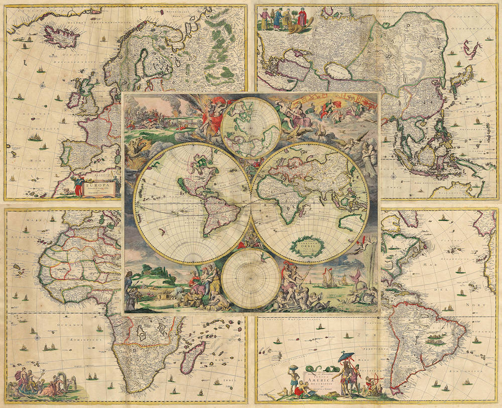
This matching set by Amsterdam-based engraver and publisher Gerard van Schagen comprises separate maps of the four continents—Europe, Asia, Africa, and America—alongside a double-hemisphere world map.
Issued in 1689, it represents the second state of van Schagen’s series, first published in the early 1680s.
Although little is known about van Schagen’s life, he was a skilled etcher and printer whose maps were distributed by leading Amsterdam publishers including Johannes van Keulen, Nicolaes Visscher II, and Frederick de Wit.
He did not compile atlases himself, his separately issued maps and wall charts circulated widely among merchants, navigators, and collectors.The Dutch imprint in the lower right corner of the world map reads t'Amsterdam gedruckt by G. van Schagen, by de Nieuwe Haerlemmer sluy—"Printed by G. van Schagen at the Nieuwe Haarlemmer Sluice," a lock near the Brouwersgracht and Haarlemmerstraat long associated with printers and map dealers.
Van Schagen's world map draws heavily on Frederik de Wit’s world map Nova totius terrarum orbis tabula (see View Record (#207)), first published in the Orbis maritime sea atlas around 1668.
It is framed by elaborate mythological scenes representing the four classical elements—air, fire, water, and earth—closely following the allegorical programme designed by
Romeyn de Hooghe for De Wit’s original:
Air(upper right): The Olympian gods are shown seated among clouds, each associated with one of the seven classical planets—Zeus (Jupiter), Juno (Hera), Ares (Mars), Aphrodite (Venus), Apollo (Sun), Cronus (Saturn), Hermes (Mercury), and Diana (Moon).
Overhead, a zodiac band runs from Cancer to Scorpio.
Fire(upper left): Hades (Pluto) and Persephone preside over a fiery underworld guarded by Cerberus, with scenes of war and destruction in the distance.
Water(lower right): Poseidon (Neptune) and Amphitrite appear amid tritons, sea monsters, and Dutch ships—a celebration of Dutch maritime power.
Earth(lower left): Cybele, the turret-crowned goddess of cities and agriculture, sits among symbols of abundance.
Her mural crown the fortifications of Amsterdam, expressing the city’s claim as the hub of global commerce.
The four accompanying continent maps are adapted from Nicolaes Visscher I’s c.1658 series, newly updated and embellished with allegorical
cartouches in place of Visscher’s original dedications:
America: California is shown as an island.
At the top right, Poseidon (Neptune) rides his seahorse-drawn chariot.
Asia:
Incorporates Abel Tasman’s 1644 discoveries in northern Australia.
At the top right, a vignette shows figures in diverse Asian attire, including one weilding a stick above a collared beaver-like.
Africa: The lower left corner features Poseidon (Neptune) with a semi-naked maiden in a seahorse-drawn chariot—a classical motif of maritime dominance.
Europe: At the bottom right, a maiden draped in red rides a bull across the sea, referencing the myth of Europa from Ovid’s Metamorphoses2:836–875.
Together, these maps combine updated cartographic content with classical imagery, projecting the cultural confidence and global ambitions of the Dutch at the close of the seventeenth century.
Schagen, Gerard van (1642–1690)
Separate publication: Amsterdam: Gerard van Schagen, 1682
1689, Second
Copperplate engraving
514
R1 Extremely rare - occasionally seen on the market