
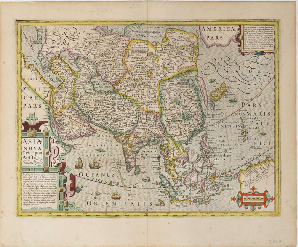
Asiae nova descriptio
Jodocus Hondius I was a Flemish engraver, instrument maker, and map publisher whose career moved between Ghent, London, and Amsterdam.
After leaving Ghent during the religious turmoil of the 1580s, he worked in London, where he became familiar with English maritime circles and with information surrounding Sir Francis Drake’s circumnavigation.
In 1593 he settled in Amsterdam, and in 1604 acquired a large group of Gerard Mercator’s atlas plates.
From 1606 he issued an expanded version of Mercator’s atlas, now generally known as the Mercator-Hondius atlas series.
This map of Asia was first published in the 1606 Mercator-Hondius atlas and is represented here by the 1623 seventh issue.
It presents Asia from the eastern Mediterranean and Arabia to Japan, China, Southeast Asia, the East Indies, and New Guinea.
The map combines inherited Mercatorian geography with newer information drawn from Iberian, Portuguese, Dutch, and travel-book sources.
The East Indies and Southeast Asia are particularly important.
Hondius’s treatment draws on sources including Jan Huygen van Linschoten’s Itinerario and Theodor de Bry’s Petits Voyages.
Korea is shown as an island, while Japan appears with its principal islands in an enlarged and somewhat distorted form.
Java is incomplete, and the surrounding island geography reflects the still-developing European understanding of Southeast Asia and the western Pacific.
New Guinea appears at lower right, labelled Nova Guinea, with Spanish-derived place names.
A scale bar partly occupies the area south of New Guinea, visually covering the very zone where European knowledge was uncertain.
The accompanying inscription notes that it was not yet known whether this land was an island or part of the continent of Terra Australis.
This uncertainty is especially significant because the map first appeared in 1606, the same year that Willem Jansz. and the Duyfken explored waters off Cape York and made the first recorded European landfall on the Australian continent.
The map includes substantial textual panels.
The lower-left panel summarises ancient ideas about Asia, while the upper-right panel discusses the Anian Fretum, or Strait of Anian, the supposed passage between Asia and America.
These inscriptions show Hondius combining classical geography, recent exploration, and speculative northern and southern passages within a single image of Asia.
Within the collection, this map is closely connected with Hondius’s East Indies map (80and 272), which treats Southeast Asia and the Moluccas in greater regional detail, and Jodocus Hondius Jr.’s Nova Guinea et Ins.
Salomonis (460), which focuses on New Guinea and the Solomon Islands.
It also relates to Abraham Ortelius’s Southeast Asia map (106), the Linschoten map of Southeast Asia (74), and earlier Gastaldi/Ramusio maps of the region (28, 29, 57, and 58), which together trace the changing European mapping of Asia, the East Indies, and the uncertain southern lands.
Hondius I, Jodocus (1563–1612)
Gerardi Mercatoris Atlas, sive cosmographicae meditationes de fabrica mundi et fabricati figura Amsterdam: Jodocus Hondius, 1606
1623, Latin
1606, 1607, 1609, 1611, 1613, 1619, 1628, and 1630
Copperplate engraving
253
R3 Uncommon - dealers can usually obtain a copy