
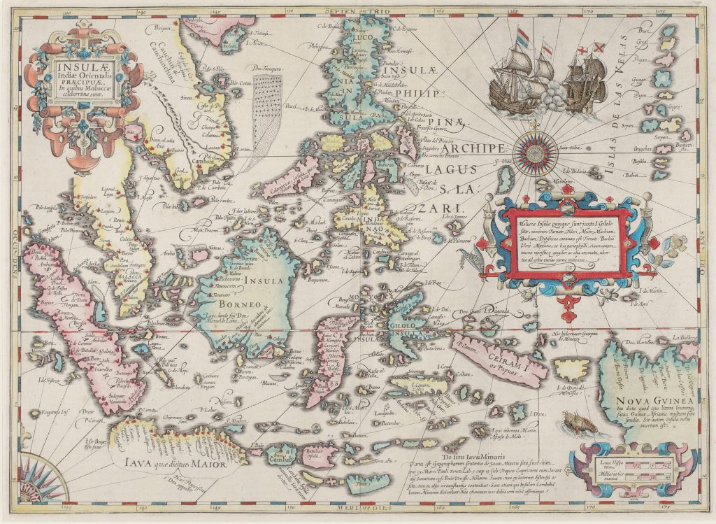
Insulae indiae orientalis praecipuae in quibus Moluccae celeberrime sunt
Jodocus Hondius I was a Flemish engraver, instrument maker, and map publisher whose career moved between Ghent, London, and Amsterdam. After leaving Ghent during the religious turmoil of the 1580s, he worked in London, where he became familiar with English maritime circles and with information surrounding Sir Francis Drake’s circumnavigation. In 1593 he settled in Amsterdam, and in 1604 acquired a large group of Gerard Mercator’s atlas plates. From 1606 he issued an expanded version of Mercator’s atlas, now generally known as the Mercator-Hondius atlas series.
This map was first published in the 1606 Mercator-Hondius atlas. It focuses on the East Indies, with particular attention to the Moluccas, Java, Borneo, Sumatra, the Malay Peninsula, the Philippines, New Guinea, and the surrounding seas. The title identifies the Moluccas as the most celebrated of the East Indian islands, reflecting their centrality to the European spice trade. The map is especially notable for its reference to Drake's passage through Southeast Asian waters. Hondius marks Drake’s landfall on the southern coast of Java with the inscription Huc Franciscus Dra. and a dotted line, indicating the reported course of his voyage. The nearby depiction of Sulawesi, here labelled Gilolo, recalls the dangerous coast where Drake’s expedition nearly came to disaster. These details make the map one of the few printed maps of Southeast Asia to register Drake’s presence in the region, and they reflect Hondius’s access to English voyage information during his years in London. This detail is closely connected with Hondius’s portrait of Drake (212), which presents the English navigator as a figure of global maritime achievement.
Hondius’s map combines Dutch, English, Iberian, and Portuguese-derived information. Inscriptions discuss the spices of the Moluccas, including cinnamon, nutmeg, cloves, and ginger, and record conflicting ideas about the location of Java Minor. New Guinea is described with uncertainty: Hondius notes its resemblance in name to Guinea in Africa and leaves open the question of whether it is an island or part of a larger southern landmass. Other notes refer to Dom Manuel de Lima’s visit to Borneo and Martin Afonso de Melo’s wintering place, drawing on Portuguese sources that probably derived from charts associated with Bartolomeu Lasso.
Within the collection, this first issue can be compared with the later 1619 issue of the same map (272). It also relates to Hondius’s larger map of Asia (253), where New Guinea and the East Indies are placed within a broader continental frame, and to the earlier Southeast Asia maps by Lorenz Fries (1 and 2), Giacomo Gastaldi (57 and 58), and Giovanni Battista Ramusio/Gastaldi (28and 29). Together, these works show how European printed maps gradually shifted Southeast Asia from inherited classical and travel-text geography toward a more maritime, trade-oriented, and voyage-informed cartography.
Hondius I, Jodocus (1563–1612)
Gerardi Mercatoris Atlas, sive cosmographicae meditationes de fabrica mundi et fabricati figura, Amsterdam: Jodocus Hondius, 1606
1606, first
1607, 1609, 1611, 1613, 1619, 1623, 1628, and 1630
Copperplate engraving
80
R2 Very rare - one or two copies appear on the market