
Pascaerte Vande Zuyd-Zee
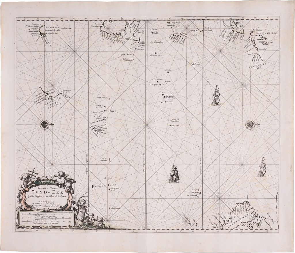
Pieter Goos was an Amsterdam chartmaker and publisher whose work helped circulate Dutch maritime geography beyond official VOC manuscript channels. His Pascaerte Vande Zuyd-Zee belongs to the second wave of printed charts incorporating the discoveries of Abel Tasman’s voyages of 1642–1643 and 1644. Unlike the large-format wall maps and more formal atlas maps associated with Joan Blaeu, Goos’s chart presents a commercial nautical synthesis of recent Dutch knowledge of the Pacific and the southern seas.
The chart of the South Sea covers the Pacific from California and the western coast of the Americas to the Ladrones, Japan, New Guinea, Compagnies Land, Hollandia Nova, Van Diemens Landt, and Zeelandia Nova. The chart is oriented with west at the top, a convention that reflects Dutch nautical practice and the chart’s intended use as a working sea chart rather than a conventional terrestrial map. The chart gives particular prominence to Tasman’s discoveries. Van Diemens Landt appears at upper left, recording the island now known as Tasmania, while Zeelandia Nova appears below it with coastal names from Tasman’s voyage. To the north and west, the chart includes parts of Hollandia Nova, New Guinea, the Solomon Islands, the Ladrones, and other Pacific islands. The open spaces of the Pacific are structured by rhumb lines, compass roses, latitude and longitude scales, and sailing routes, showing the ocean as a navigable field of movement rather than an empty expanse.
The cartouche at lower left identifies the chart as a product of Pieter Goos’s Amsterdam publishing house and includes scale bars in Dutch, Spanish, and English miles. Putti with navigational instruments, compass roses, and ships reinforce the chart’s maritime function. The chart presents the Pacific as a practical oceanic space shaped by Dutch, Spanish, and broader European navigation.
Within the collection, this chart is closely connected with Goos’s East Indies chart (307), since together they show how Dutch sea-atlas publishing connected Southeast Asia, the Pacific, and the known parts of Hollandia Nova, Van Diemens Landt, and Zeelandia Nova. It also relates to Goos’s world map (115), where the same southern discoveries are placed within a global double-hemisphere framework. For Tasman’s discoveries and VOC knowledge of Australia and the western Pacific, it provides a useful comparison with the collection’s examples of Joan Blaeu’s Archipelagus Orientalis sive Asiaticus (76, 108, 121).
Goos, Pieter (c. 1616–1675)
Separate publication. Amsterdam, 1666
1666, first
Copperplate engraving
466
R2 Very rare - one or two copies appear on the market