
A Large Draught from Benjar on the Island of BORNEO, to Macasser on the Island of CELEBES
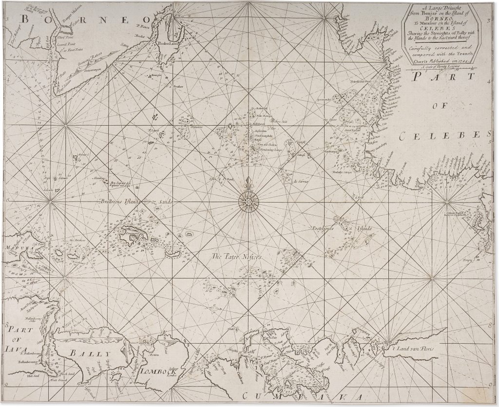
Samuel Thornton, the son of John Thornton, continued the Thornton chartmaking business after his father’s death in 1708. He issued a new edition of The English Pilot. The Third Book … the Oriental Navigation in 1711, but after his death in 1715 the plates and publishing stock were later used by Mount & Page. They continued to issue The English Pilot through the eighteenth century, revising, correcting, and reprinting earlier Thornton charts. The fuller title wording records: A Large Draught from Benjar on the Island of BORNEO, to Macasser on the Island of CELEBES Shewing the Streights of Bally with the Islands to the Eastward thereof.
The present example is a later corrected issue produced by Mount & Page. Centred on the eastern Java Sea and the island passages between Borneo, Java, Bali, Lombok, Sumbawa, Flores, and Celebes, it records a strategically important navigational zone linking Java with the Makassar Strait, the Moluccas, and routes further east. Oriented for practical navigation, the sheet gives close attention to coastlines, shoals, soundings, islands, anchorages, rhumb lines, and compass roses rather than inland geography. Banjarmasin appears on Borneo, Macassar on Celebes, now Sulawesi, and the central island group is labelled The Pater Nosters. Flores is identified by the Dutch form ’t Land van Floris, preserving the Dutch hydrographic inheritance on which much English chartmaking for the East Indies depended.
The waters shown were difficult and commercially important. Mariners sailing between Java, the Makassar Strait, the Moluccas, China, and the wider routes toward New Holland had to negotiate narrow passages, reefs, shoals, monsoon winds, and complex island chains. The corrected issue reflects the continuing revision of earlier Thornton charts by later London publishers using additional European hydrographic sources.
Within the collection, this chart is closely connected with Thornton’s more detailed chart of the east end of Java, Madura, and the Bali Strait (399), which enlarges one of the key passages shown here. It also relates to Thornton’s chart of the coast of New Holland (102), since the same volume presented English navigators with connected routes through Southeast Asia and toward Australia’s western coast. John Seller’s earlier chart of the eastern East Indies and New Holland (53) provides an earlier English comparison, while Samuel Dunn’s later chart of the Sunda Strait (419) shows the continuing importance of English charting around Java in the eighteenth century.
Thornton, Samuel (1665–1715)
The English Pilot. The Third Book … the Oriental Navigation, London: John How and Samuel Thornton, 1711
1745, Mount & Page corrected issue
Copperplate engraving
398
R2 Very rare - one or two copies appear on the market