
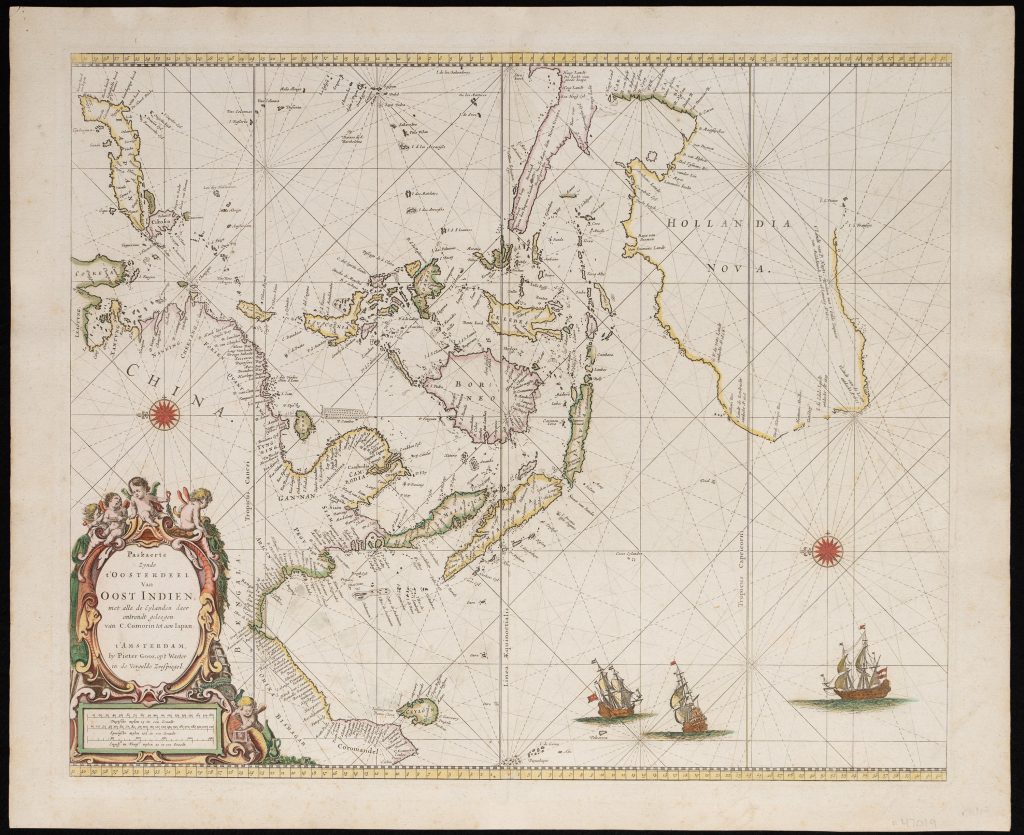
Paskaerte Zynde t'Oosterdeel Van Oost Indien, met alle de met alle de Eylanden daer ontrendt geleegen van C. Comorin tota aen Iapan
Pieter Goos was an Amsterdam chartmaker and publisher whose work belongs to the commercial Dutch sea-atlas tradition of the later seventeenth century. The son of the engraver and mapmaker Abraham Goos, he built a successful publishing business around pilot books, sea charts, and maritime atlases. His Zee-Atlas ofte Water-Wereld, first published in Amsterdam in 1666, presented Dutch nautical geography in a large and visually ambitious format.
The chart records early Dutch and English encounters with the Australian coast. In northern Australia, Goos incorporates discoveries from Abel Tasman’s second voyage of 1644, with the continent labelled Hollandia Nova. Along the western and southern coasts he records earlier Dutch contacts, including Dirk Hartog’s 1616 landfall in the Eendracht, commemorated in ’t Landt van d’Eendracht and Dirck Hartogs ree; the 1619 sightings by Frederick de Houtman and Jacob d’Edel, associated with d’Edelsland and the Houtman Abrolhos; the 1622 voyage of the Leeuwin, recorded in ’t Landt vande Leeuwin; Jan Carstensz.’s 1623 voyage in the Pera and Arnhem, which charted parts of New Guinea’s south coast and the western side of Cape York Peninsula; Pieter Nuyts’s 1627 exploration of the southern coast, recorded in ’t Landt van P. Nuyts; and Gerrit Frederiksz. de Witt’s 1628 encounter with the north-west coast. The chart also notes the English wreck of Captain John Brookes’s Trial near the Montebello Islands in 1622, marked by the Trial Rocks.
Within the collection, this chart is closely connected with Goos’s Pascaerte Vande Zuyd-Zee (466), which extends Dutch nautical geography across the Pacific, and his double-hemisphere world map (115), where the same southern discoveries are placed within a global framework. It It also provides a useful comparison with the collection’s examples of Joan Blaeu’s Archipelagus Orientalis sive Asiaticus (76, 108, 121), where Tasman’s discoveries and VOC knowledge of Australia and the western Pacific were incorporated into a more formal atlas map.
Goos, Pieter (c. 1616–1675)
De Zee-Atlas ofte Water-Wereld, Amsterdam: Pieter Goos, 1666
1669
Copperplate engraving
307
R3 Uncommon - dealers can usually obtain a copy