
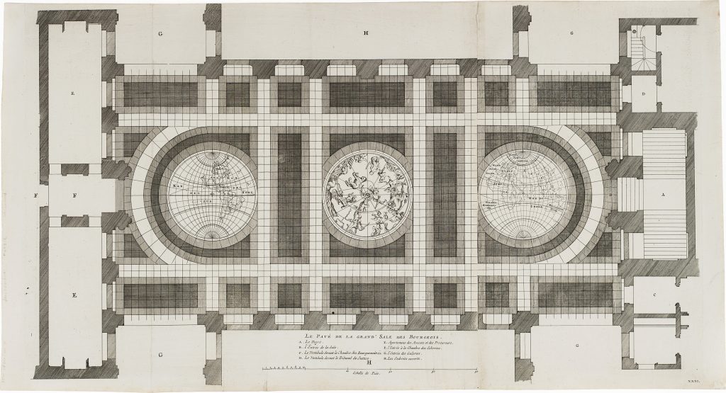
Le pavé de la grand' sale des bourgeois
Jacob van Campen was a Dutch artist and architect who designed Amsterdam’s new Town Hall. Construction began in 1648 and the building opened in 1655. Van Campen’s design was first published in Afbeelding van ’t Stadt huys van Amsterdam. In dartigh Coopere Plaaten geordineert, issued in Amsterdam by Dancker Danckerts in 1661, with the plates drawn by Jacob Vennekool (see # link).
This engraving records the pavement of the Burgerzaal, the great citizens’ hall at the centre of Amsterdam Town Hall. The French title, Le pavé de la grand’ sale des bourgeois, identifies the subject as the floor of the “great hall of the burghers.” The pavement was designed as a cartographic and celestial ensemble: a celestial map occupied the centre, flanked by large terrestrial maps of the eastern and western hemispheres. Each terrestrial hemisphere measured more than six metres in diameter and was executed in copper and coloured marble. The design turned the civic hall into a cosmographic space. Visitors entering through the portals at either end of the hall crossed a floor that placed Amsterdam symbolically within the wider world. The engraved plan marks the entrances and architectural correspondences with letters, including portals identified on the floor plan and linked to elevations elsewhere in the architectural publication. In this way, the plate functions both as a record of the floor design and as part of the larger visual explanation of the building.
The cartographic content is significant. One hemisphere includes Hollandia Nova, reflecting Dutch knowledge of Australia and Tasmania after the voyages associated with Abel Tasman. The other includes North and South America, with California shown as an island, a persistent seventeenth-century cartographic misconception. These details connect the floor to the mapmaking and maritime culture of Amsterdam, where global trade, navigation, and civic power were closely intertwined. This example is a 1719 reissue of a plate first published in Van Campen’s 1661 architectural work. Over time, the original inlaid floor became worn and the maps were eventually filled in, making engraved records such as this important evidence for the original appearance of the Burgerzaal. The idea of a monumental floor map later found an echo in Australia: in 1946, the State Library of New South Wales commissioned a marble floor map for its main vestibule, drawing inspiration from the Amsterdam design.
Campen, Jacob van (1595–1657)
Afbeelding van ’t Stadt huys van Amsterdam. In dartigh Coopere Plaaten geordineert, Amsterdam: Dancker Danckerts, 1661
1719
Copperplate engraving
281