
Secunda etas mundi / World map from the Nuremberg Chronicle
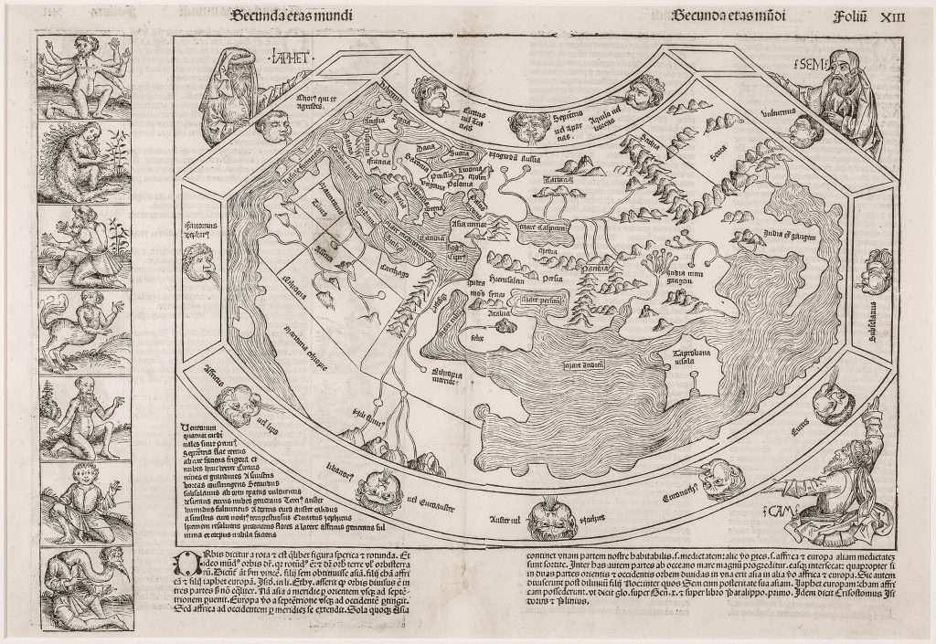
Hartmann Schedel was a German physician, humanist, and book collector best known as the compiler of the Liber chronicarum, or Nuremberg Chronicle, printed in Nuremberg by Anton Koberger in 1493. The book was an illustrated history of the Christian world, extending from Creation to the time of publication. It was financed by the Nuremberg merchants Sebald Schreyer and Sebastian Kammermeister, who commissioned Schedel to compile the text. A German edition, Das Buch der Croniken und Geschichten, was published later in the same year and also included a world map. This woodcut world map appears in the Latin edition in the section headed Secunda etas mundi, the second age of the world. The Latin and German editions can be distinguished by their text and page setting: in the Latin edition, as here, the map appears above the accompanying Latin text. The map was probably derived from the frontispiece map in Pomponius Mela’s Cosmographia, published in Venice in 1482, and preserves a conservative classical and medieval image of the inhabited world.
The map presents Asia, Europe, and Africa within a surrounding ocean, with the Indian Ocean still enclosed by land. This is significant because Bartolomeu Dias had rounded the southern tip of Africa in 1488, five years before the Nuremberg Chronicle was printed. The map therefore records not the newest navigational knowledge, but the persistence of an older Ptolemaic and medieval geographical structure in early print. The map is surrounded by twelve named wind heads. The accompanying Latin text describes the qualities of the winds, including cold northern winds, dry and cloudy eastern winds, moist and storm-bearing southern winds, and western winds associated with the end of winter and the coming of blossoms. These winds frame the world as a cosmographical system, linking geography with climate, direction, and natural philosophy.
Outside the map’s frame are the three sons of Noah: Shem, Ham, and Japheth. The text below explains that the spherical earth is divided into three principal landmasses, each assigned to one of Noah’s descendants: Asia to Shem, Europe to Japheth, and Africa to Ham. Geography is therefore presented through biblical history as well as through classical learning. A vertical strip at the left shows seven monstrous or marvellous races, printed from a separate woodblock. These include a six-armed figure, a hairy woman, a man with six fingers on each hand, a hippocentaur, a bald woman with a long beard, a four-eyed man, and a crane-necked figure with a beak-like mouth. Such figures were believed in classical and medieval tradition to inhabit distant parts of the world. Their presence reminds the reader that the Nuremberg Chronicle treated geography not only as a matter of places and coastlines, but also as a history of peoples, marvels, and the limits of Christian knowledge.
Within the collection, this map is closely connected with other early printed and cosmographical world maps, especially Gregor Reisch’s Typus universalis terrae (103), which shows a later pedagogical attempt to organise the world according to “modern” divisions.
Schedel, Hartmann (1440–1514)
Liber chronicarum, Nuremberg: Anton Kroberger, 1493
1493, first, Latin
1493, second, German edition, 23 December, with text above the map
Woodcut
127
R2 Very rare - one or two copies appear on the market