
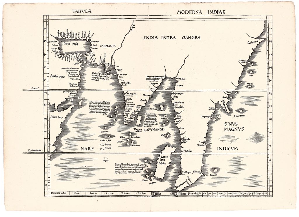
Tabula moderna Indiae
Martin Waldseemüller was a German cartographer, geographer, and humanist scholar whose work helped reshape European understanding of the world during the early sixteenth century. Educated at the University of Freiburg, he later joined the humanist circle known as the Gymnasium Vosagense at Saint-Dié in Lorraine. There, working with Matthias Ringmann and other scholars, he produced a series of influential geographical publications, including the 1507 wall map that first applied the name America to the newly recognised western continent.
Published by Johann Schott in Strasbourg in 1513, Waldseemüller’s edition of Ptolemy's Geographia combined twenty-seven maps based on Ptolemy’s second-century geography with twenty modern maps incorporating information from recent Portuguese and Spanish exploration. It was the first printed edition of Ptolemy to include a substantial supplement of modern maps alongside the traditional Ptolemaic series, and a second edition was issued in 1520 using the same woodblocks. This map, Tabula moderna Indiae, belongs to the modern supplement and presents a contemporary view of the Indian Ocean, India, Southeast Asia, and adjacent regions. Waldseemüller based it largely on a manuscript world chart made around 1506 by the Genoese mapmaker Nicolo Caveri, now preserved in the Bibliothèque nationale de France. By this time, Bartolomeu Dias had rounded the Cape of Good Hope in 1487, and European mapmakers were beginning to abandon Ptolemy’s enclosed Indian Ocean. Henricus Martellus had already opened the Indian Ocean in his world map of around 1489 by removing the southern landmass that Ptolemy had imagined as connecting southern Africa to Asia.
The contrast with Waldseemüller’s Ptolemaic map of the same broad region (61) is significant. Where the Ptolemaic map is filled with rivers, mountains, marvels, and inherited classical island lore, this modern map has a largely empty interior and a more open maritime geography. Ptolemy’s cannibals, tailed peoples, magnetic islands, and Aurea Chersonesus disappear. In their place appears a huge unnamed peninsula extending into the Indian Ocean, with a large island labelled Taprobana near its western coast. Waldseemüller closely followed Caveri’s coastal geography and adapted long inscriptions describing the commodities of major Indian Ocean trade centres. Cambaia is associated with lac, fine cloth, dried fruits, incense, amber, perfumes, and seed pearls. Calicut is described through its trade in cinnamon, ginger, cloves, sandalwood, and other spices, and is explicitly connected with Portuguese discovery. Morachim is associated with cinnamon, spices, pearls, and trade with Calicut. Taprobana is described as a large island rich in gold, sapphires, ginger, spices, and overseas trade.
Within the collection, this map is closely connected with Waldseemüller’s Undecima Asiae tabula (61), its Ptolemaic counterpart from the same atlas. The two maps were intended to be viewed together, allowing readers to compare ancient and modern geographical knowledge. Where the Ptolemaic map presents a landscape shaped by classical texts, marvels, and inherited geographical traditions, this modern map reflects the commercial realities of the early sixteenth-century Indian Ocean and the impact of Portuguese exploration. Together they document one of the most significant shifts in the history of cartography: the replacement of ancient geographical authority with knowledge derived from direct observation, navigation, and overseas trade.
Waldseemüller, Martin (1470–1520)
Geographiae opus nouissima traductione e Graecorum archetypis castigatissime pressum, Strasbourg: Johann Schott, 1513
1513, first
1520, second, using the same woodblocks
Woodcut
63
R2 Very rare - one or two copies appear on the market