
New Guinea, New Britain and New Holland &c.
Herman Moll was a German-born cartographer, engraver, and publisher who established his career in London in the late seventeenth century and became one of the city’s leading commercial mapmakers in the early eighteenth century. His maps often combined geographical compilation with commercial and political commentary, reflecting Britain’s expanding interest in global navigation, trade, and colonial rivalry.
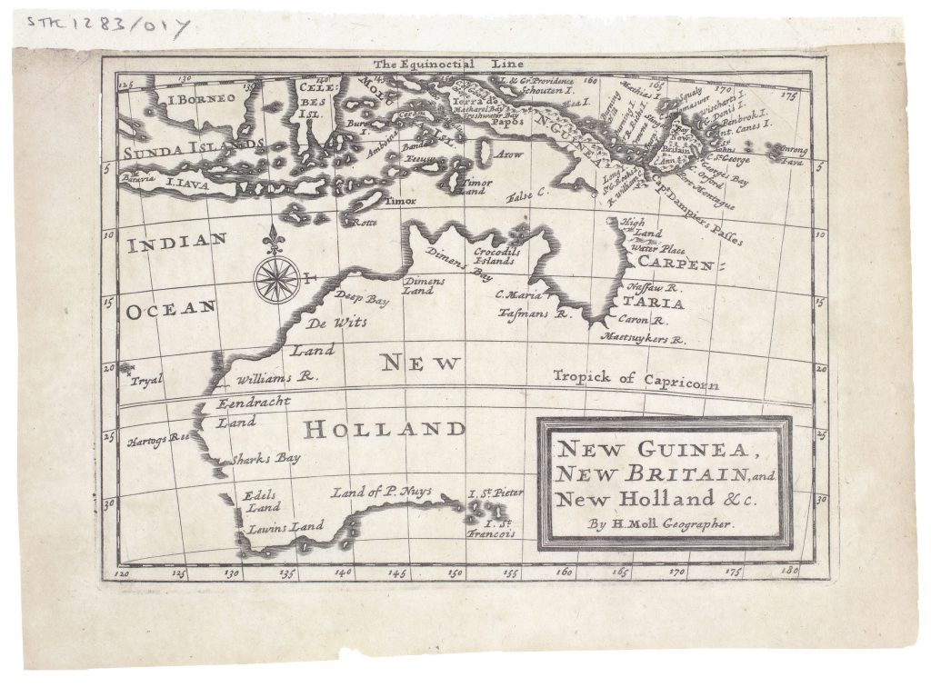
This small map was published in Moll’s Atlas Geographus: or, A Compleat System of Geography, issued in monthly parts between 1711 and 1717 and completed as a five-volume work in 1717. While volume five covered the Americas it included a chapter on Terra Australis Incognita, and this map. Although modest in size, the map is important as an early English printed map focused on New Holland and the surrounding southwest Pacific. New Holland is shown as a set of partial coastlines rather than a completed continent. Many of the names come from Dutch voyages and landfalls made during the seventeenth century. The western coast includes Eendracht Land and Hartogs R., which recalls Dirk Hartog’s 1616 landing in the Eendracht; De Wits Land refers to Gerrit Frederiksz. de Witt’s voyage of 1628; and Edels Land, Leeuwins Land, and Land of P. Nuys preserve further Dutch coastal discoveries along western and southern Australia. To the north Diemens Land, Groote Eylandt, Carpentaria, and rivers such as the Nassaw R., Caroon R., and Maersuykers R. reflect Dutch exploration of the Gulf of Carpentaria and Arnhem Land. The result is a map built from coastal encounters rather than a fully known continental outline.
The map also shows the growing English interest in the region after William Dampier’s voyages. Moll records Dampier’s discoveries at Shark Bay and the strait between New Guinea and New Britain. Some Dutch names are imperfectly transmitted, including R. Coen, from Jan Carstensz.’s 1623 discoveries in Cape York, which appears here as Caron R. These details show how Dutch and English information were being combined, copied, and sometimes misread in early eighteenth-century printed geography.
Within the collection, this map is closely connected with Johannes Loots’s Indian Ocean chart (4), Johannes van Keulen II’s chart of the western coast of Hollandia Nova (139), Johannes van Loon’s Pacific chart showing Van Diemens Lant (290), and Jan de Lat’s map of Nieu Holland (389). It also relates to Pierre Mariette’s Carte Generale des Indes Orientales et des Isles Adiacentes (354), which shows an earlier French adaptation of Dutch information about Southeast Asia and Australia.
Moll, Herman (1654–1732)
Atlas Geographus: or, A Compleat System of Geography (Ancient and Modern) for America, vol. 5, London: John and Elizabeth Nutt, 1717
1717, first
Copperplate engraving
27
R2 Very rare - one or two copies appear on the market