
La Nuova Olanda e la Nuova Guinea delineato sulle ultime osservazioni
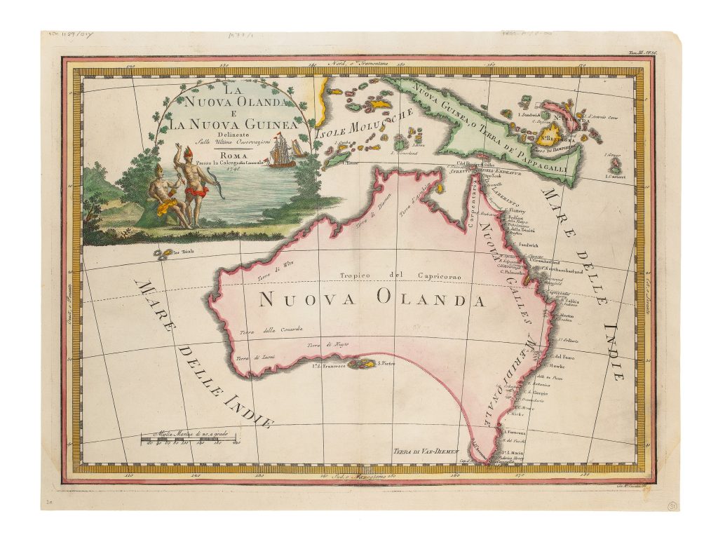
Giovanni Maria Cassini was a Roman geographer, engraver, and publisher active in the late eighteenth and early nineteenth centuries. His Nuovo atlante geografico universale was published in Rome between 1792 and 1801 in three volumes, and was one of the largest Italian atlases of the period. The atlas drew on recent European geographical observation and exploration. This map presents Australia, New Guinea, and the surrounding seas at a moment when the outline of the continent was still incomplete. Cassini’s related terrestrial globe gores, first issued in 1790 and later incorporated into the Nuovo atlante geografico universale, are also represented in this collection (87).
The map shows Australia as Nuova Olanda and New Guinea as Nuova Guinea, O Terra de Pappagalli. The east coast incorporates the discoveries made during Captain James Cook’s first voyage in Endeavour in 1770, rendered here through Italianised nomenclature. Place names associated with Cook’s passage from Point Hicks northward to Torres Strait appear along Nuova Gales Meridionale, marking the incorporation of British Pacific exploration into an Italian atlas tradition. Much of the southern and south-eastern coastline remains provisional. Terre di Van-Diemen is linked by a dotted line to Terre di Nuyt and Nuova Gales Meridionale, reflecting continuing uncertainty about whether Van Diemen’s Land was joined to the mainland. This was before Matthew Flinders and George Bass confirmed Bass Strait in 1798–1799, and before Flinders’s circumnavigation clarified the continental outline. In the west and north-west, earlier Dutch discoveries remain prominent, including the marking of Les Trials off the coast of Western Australia.
The surrounding oceans are also revealing. The Indian Ocean, labelled Mare delle Indie, appears on both sides of Australia, showing that the modern division between the Indian Ocean to the west and the Pacific Ocean to the east was not yet consistently applied in European atlases. The map combines earlier Dutch coastal discoveries, British information from Cook’s voyage, and French naming traditions within an Italian engraved format. At upper left, a decorative cartouche shows two rigged ships and two Indigenous figures with bows and arrows. The cartouche links the map visually to exploration, maritime encounter, and European ideas of distant peoples. Like the geography itself, the imagery reflects an eighteenth-century European attempt to make the southern lands legible through a combination of observation, inherited mapping, and conventional ethnographic decoration.
According to Simon Dewez, the second state differs from the first by the alteration of the imprint: rafia was inserted after Calcog., completing Calcografia, and Camerale was re-engraved and shifted slightly to incorporate the addition. The change is a plate alteration and should therefore be recorded as a state, while the atlas publication should be described separately as the issue. See also Cassini’s related terrestrial globe gores in this collection (87).
Cassini, Giovanni Maria (1745–1824)
Nuovo atlante geografico universale: delineato sulle ultime osservazioni, vol. 3, Rome: Calcografia Camerale, 1792
1798, second with rafia inserted after Calcog.
Copperplate engraving
15
R3 Uncommon - dealers can usually obtain a copy