
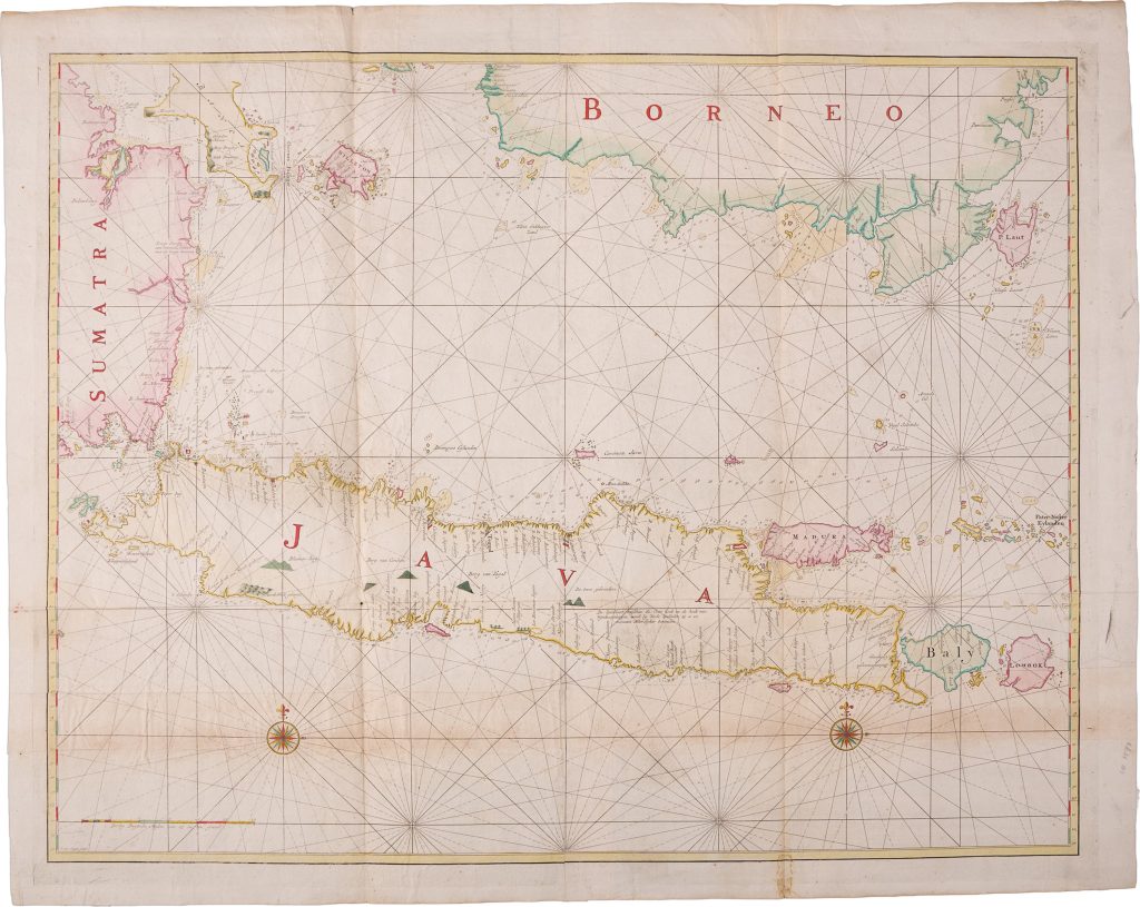
Blueback sea chart of Java
Johannes van Keulen II belonged to the third generation of the Van Keulen publishing house, In de Gekroonde Lootsman (“In the Crowned Pilot”), one of Amsterdam’s leading producers of sea charts, pilot books, and maritime atlases.
In 1753 he issued the sixth and final volume of De nieuwe groote lichtende Zee-fakkel, a restricted VOC volume devoted to Asian and Indian Ocean navigation.
After his death in 1755, the firm continued to issue large working charts for Dutch navigation in Asian waters.
This large blueback sea chart of Java was first published in Amsterdam in 1757 and, according to The Van Keulen Cartography, was made between 1757 and 1779.
It was issued separately for use aboard VOC ships rather than as a standard atlas chart.
The chart is engraved and signed by Jan van Jagen, one of the important Dutch chart engravers of the period.
The chart records Java and adjacent waters in dense hydrographic detail, including depth soundings, shoals, reefs, coastal cliffs, safe anchorages, useful landmarks, rhumb lines, and compass roses.
Its large format and blueback mounting indicate practical shipboard use, while its detailed coastal information reflects the continued importance of Java to VOC navigation and administration in Southeast Asia.
A notable feature is the extensive textual note in the interior of Java, which records a correction to the position of the south coast: De Zuidkust tusschen de Oost hoek en de hoek van Wynkoopsbergen word by Veele Zeelieden 15 a 20 minuten Noordlyker bevonden ("The south coast between the East point and the point of Wynkoopsbergen is found by many sailors 15 to 20 minutes further north").
This note shows how the chart incorporated practical observations from mariners and corrected earlier coastal geography.
This chart is closely connected with Gerard van Keulen’s earlier two-sheet map of Java after Reland (261), Batavia road chart (349), and the English copy of that Batavia chart published by Robert Sayer and John Bennett (298), and Hendrik Doncker II’s Nieuwe Paskaart van het Ylandt Java (422).
Together, these works trace the increasing precision of Dutch charting around Java, from atlas maps and regional sea charts to large-format VOC working charts intended for active navigation.
Only known in one other example in the Maritime Museum in Amsterdam
Keulen II, Johannes van (1704–1755)
Separate publication.
Amsterdam: Van Keulen firm, 1757
1757, first
Copperplate engraving
468
Second copy known