
Polus Antarcticus
Henricus Hondius, the younger son of the renowned engraver and mapmaker Jodocus Hondius I, played a key role in the family mapmaking business, known as "In de Wackere Hondt" ("In the Vigilant Dog") in Amsterdam.
Henricus worked closely with his father to expand and republish Gerard Mercator’s famous world atlas.
Mercator passed away in 1594, leaving his ambitious Atlas unfinished.
Mercator’s son, Rumold, completed and published the work in 1595 under the title Atlas sive Cosmographicæ meditationes de fabrica mundi et fabricati figura.
A subsequent edition followed in 1602 but it was not commercially successful.
After Rumold’s death in 1599, Jodocus Hondius I acquired many of the copperplates from Mercator’s atlas and used these along with his own maps to publish a new edition in 1606, titled Gerardi Mercatoris, Atlas sive cosmographicae meditationes.
Hondius kept Mercator's name as the author and listed himself as the publisher.
This edition, known as the Mercator-Hondius Atlas, was highly successful, solidifying the Hondius family’s prominence in the cartographic world.
Following Jodocus I death in 1612, his sons Henricus and Jodocus II took over the business and continued publishing the atlas.
In 1629, after Jodocus II's death, thirty-seven of the copperplates were sold to their competitor, Willem Jansz.
Blaeu.
Blaeu modified these plates and incorporated them into his own world atlas, Atlantis appendix sive pars altera, published in 1630.
In response, Henricus partnered with his brother-in-law, Johannes Janssonius, and commissioned new plates to replace those sold to Blaeu.
Together, they published a supplement to the Mercator-Hondius Atlas, titled Atlantis maioris appendix, sive pars altera, also in 1630, as a direct competitor to Blaeu’s atlas.
It continued to be updated and expanded for several decades with new editions released throughout the 17th century.
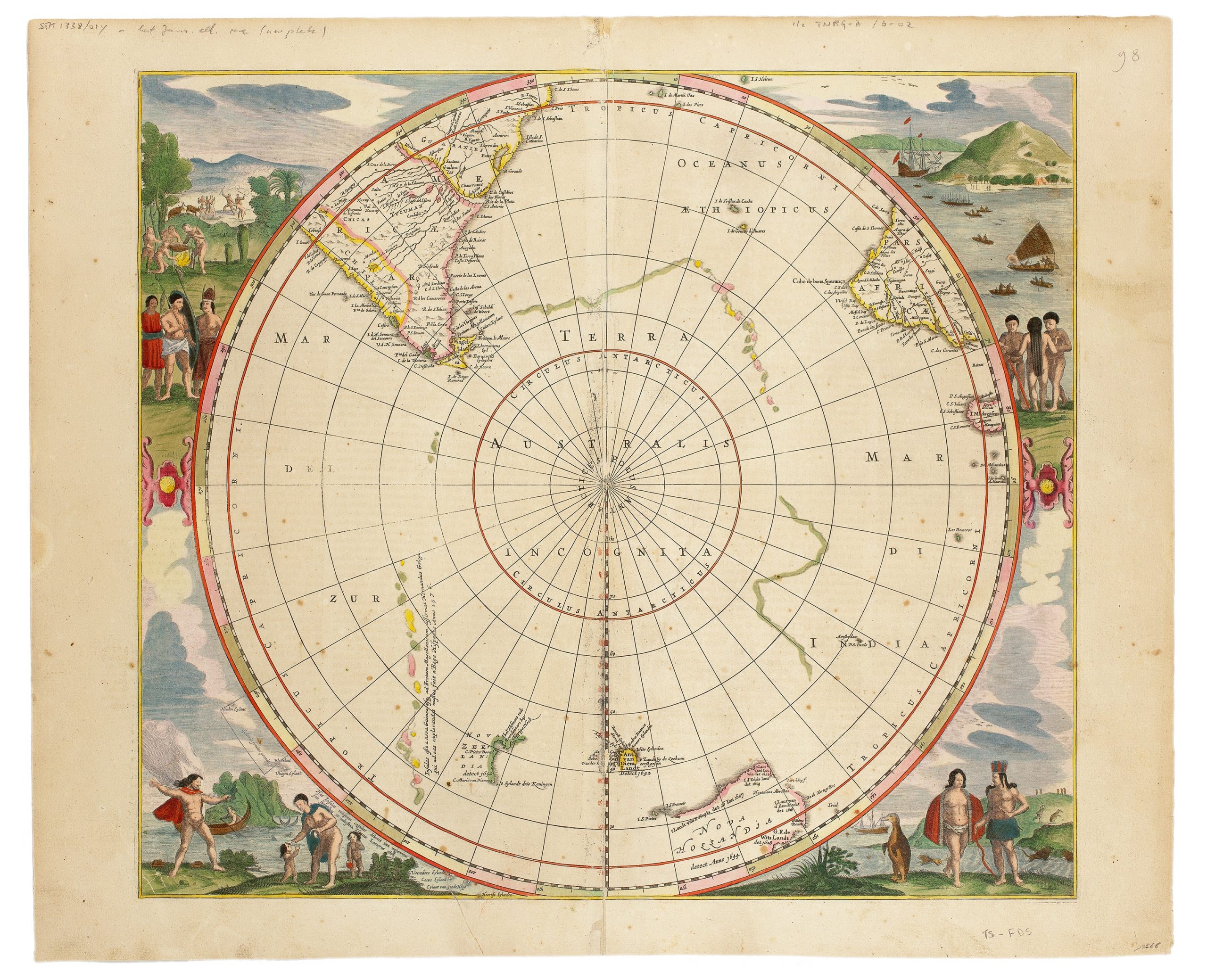
One of the most notable maps included in theAtlantis maioris appendixis this hemispherical map centred on the South Pole.
It first featured in the 1637 edition of the atlas, a period marked by intense exploration, particularly by Dutch navigators mapping the southern hemisphere's coasts and islands.
The map was revised and reissued over the next six decades, with contributions from Johannes Janssonius, Frederick de Wit, Gerard Valk, and Pieter Schenk.
State 1 (View Record (#114)): The original version of the map, published by Henricus Hondius, includes his name and the map’s title within a decorative cartouche, along with a blank cartouche nearby.
It documents the known Dutch discoveries in Australia up to 1627, such as Dirk Hartog's 1616 landing, the Leeuwin’s in 1622, and Pieter Nuyts' exploration in 1627.
The map also features Frederick de Houtman's 1619 discoveries of "Houtman's Abrollos," along with the "Trial" Islands, "I.
S.
Pieter," and "I.
S.
Francois" off Australia’s southern coast.
The inscription between the cartouches reads: "Infulas esse a nova Guinea usq. ad Fretum Magellanicum, affirmat Hernandus Galego, qui ad eas explorandas missus fuit a Rege Hispaniae Anno 1576," claiming that islands extended from New Guinea to the Strait of Magellan based on Hernando Gallego’s 1576 exploration for Spain.
These islands also appeared on other maps including Johanne Jansionius’s Mar del Zur Hispanis Mare Pacificum (#43 and 282).
Another inscription outside the map circle, at the lower left, states: "Has Insulas suis sumptibus nunquam cognitas detexit tam memorab. iss. nauclerus & explorator Iac.
Lemaireus 1618," highlighting Jacob Le Maire’s 1618 discovery of these previously unknown islands.
State 2: In 1645, Hondius’s name was replaced with Janssonius’s.
State 3: By 1650, the blank cartouche was removed, and the region "Staten Landt," which appeared in the first two states as the eastward-extending coastline from Tierra del Fuego, was renamed "Staten Eylant" after Hendrik Brouwer’s discoveries in 1644.
State 4 (this map): In 1657, the title cartouche was removed, and Abel Tasman’s discoveries in Tasmania and New Zealand were added.
These regions were marked as "Ant. van Diem.
Landt" (Tasmania) and "Nova Zeelandia" (New Zealand), with Tasman’s place names included.
The fourth state also introduces two new islands, Paulo and Amsterdam, which were not included in earlier states.
The map is further adorned with large vignettes in each corner, depicting native scenes, animals, birds, boats, and even a representation of a penguin.
On the verso is ‘Polus Antarcticus cum regionibus subjacentibus et maribus illum alluentibus’ (The Antarctic pole with the adjoining regions and seas flowing near it).
Hondius, Henricus (1597–1651)
Atlantis maioris appendix, Amsterdam: Henricus Hondius, 1637
1652, Fourth
Copperplate engraving
18
Uncommon